1. 引言
WorldView-2是DigitalGlobe公司于2009年10月发射成功的新一代高分辨率8波段商用卫星。是DG公司迄今为止发射的分辨率最高的商业遥感卫星,能以1.8 m的分辨率采集多光谱影像和以0.46m的分辨率采集全色影像。WorldView-2卫星能够提供独有的8波段高清晰卫星影像数据,与QuickBird卫星数据相比,除能提供4个常规标准波段(蓝、绿、红和近红外)外,还增加了海岸波段、黄色波段、红边波段和近红外2波段,从而提供更多的地学细节信息,用于更精确的地物信息提取,更全面地分析图像中的各种要素[1] [2] 。
归纳WorldView-2影像的特点,具有以下优势:(1) 高光谱分辨率、高空间分辨率、高时间分辨率、高辐射分辨率、高定位精度、丰富的几何纹理信息特征;(2) 影像地物的几何结构和纹理特征明显,比如,河渠池圹、水利工程等都清晰可见。因此,WorldView-2数据可为众多应用领域提供丰富、实时的数据资料。然而,当前高分辨率遥感影像中所包含的丰富信息并没有被充分的挖掘和利用[3] 。故此,采用适应的算法,通过影像 + 知识的地学分析,开展快速、准确地识别和提取影像中有效的地物信息,将遥感数据转化为行业应用需要的专题信息,已成为当前遥感广泛应用的迫切要求和面临的挑战[4] 。
为了更好地提取高分辨率遥感影像的信息,更有效合理地利用这些数据,面向对象的遥感影像信息提取技术应运而生[5] 。因为面向对象的分类技术能适应高分辨率遥感影像的特点,能提高专题信息提取的精度和速度,同时该技术更能贴近人类认知过程,因而,它已成为遥感影像处理研究的一个热点领域[6] ,如凌成星利用WorldView-2八波段影像和面向对象提取技术提取湿地信息[7] ,凌春丽等利用WorldView-2八波段影像和面向对象提取技术提取林地信息[8] 。
WorldView-2影像作为一个全新的数据源,目前国内外对它的研究还很少。本文在充分分析WorldView-2影像的8个波段的光谱特征的前提下,利用面向对象的信息提取技术,最终找到适合该影像数据的信息提取方法。
2. 研究区地理背景与数据源分析
2.1. 研究区地理背景
西安市临潼区位于陕西关中平原中部(图1),地处关中平原中部,南依骊山,东邻渭南高新技术产业开发区,西邻浐灞生态区,北邻阎良国家航空产业基地。临潼区总面积915平方公里,北纬34˚20'~34˚43'、
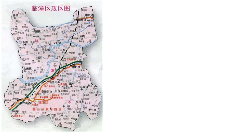
Figure 1. Sketch map of Lintong District, Xi’an City
图1. 西安市临潼区示意图
东经109˚07'~109˚49'之间。全区自然条件优越,属大陆性暖温带季风气候,四季冷暖、干湿分明,光、热、水资源丰富。水利设施齐备,农田灌溉方便,临潼主产优质小麦和玉米,是国家重点粮食生产基地。渭河平原区优质粮食生产基地面积45万亩。
2.2. 数据源分析
本文选用遥感数据是西安市临潼区的一景WorldView-2影像,数据获取时间2011年7月15日,影像范围为16.4 × 16.4平方公里。
本文的遥感影像已经辐射校正和几何粗校正,因此,直接利用西安市临潼区第二次土地利用调查1:10000数字正射影像作为参考影像先对高分辨率全色影像进行精纠正,将纠正好的高分辨率数据对低分辨率的多光谱数据进行配准。对多光谱影像和全色影像采用Pan Sharpening融合方法进行融合,得到8波段高分辨率融合影像。最后选取研究区域内5000 × 5000像元的市域范围作为区域性农田、水域及水利工程等用地进行信息提取(图2)。
3. WorldView-2影像光谱特征与应用分析
WorldView-2卫星与QuickBird卫星数据相比,其增加了4个新的光谱波段,即海岸波段、黄色波段、红边波段和近红外2波段,如图3所示。新增加的4个波段分别具有如下特征:
(1) 海岸波段Bandl(400~450 nm):海岸波段具有最大的水渗透能力,常用于水域测量,海底制图,海岸地形学分类,水体及其设施识别、水体质量检测与应用研究等。
(2) 黄色波段Band4(585~625 nm):黄波段用来检测陆生或水生植被的泛黄度,有效分辨植物种类,进行植被分析。黄波段对于碳的浓度非常敏感,可以用来检测二氧化碳的含量。与红边结合有利于植被健康度制图和精细农业实现。
(3) 红边波段Band6(705~745 nm):红边波段集中在植被响应中高反射率范围,用于识别不同的植物
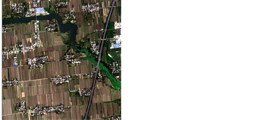
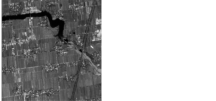
Figure 2. The panchromatic and multispectral images of the study area
图2. 研究区全色和多光谱影像
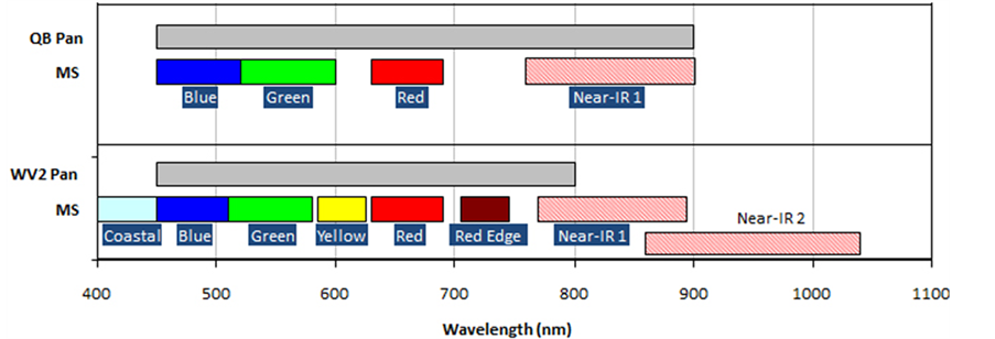
Figure 3. Contrast of WorldView-2 and QuickBird image bands
图3. WorldView-2与QuickBird影像波段对比
类别和年龄,寻找管道漏油位置。水生植物/叶绿素对700 nm左右的光谱非常敏感,所以,红边波段还可用于发现低浓度的水生植物,以及黄波段结合能够在植被分类中有效地检测健康植被与病虫害植被与死亡植被。其适用于水生植被的识别监测等分析。
(4) 近红外远端波段Band8(860~1040 nm):这个波段比陆地卫星的近红外短波波段(如ETM4波段)的900 nm高一些,使它既有高分辨率数据的特性,又具备有一定的地质制图功能,对矿山勘探工程部署、矿区地质构造解译、矿区环境及地质灾害监测等应用县有积极作用与科学意义。故其可借鉴于水利工程地质基础等信息提取。
依据本研究区农田、水体及水利设施等土地利用类型,由图2结合目视解译和实地调查,确定该研究区包含7种主要地物类型,即水体及水利设施、水草、柏油路、耕地、园地(部分草地)、林地、建设用地,剩余的裸地及部分田间小路都归为其他类别。
依据WorldView-2影像8个波段,考虑不同的波段能从不同方面反映地物信息的特性,对不同波段适用于不同地物进行解译与分类。本文根据图2影像进行目视解译,对研究区各个典型地物进行采样,用各波段均值绘制波谱响应曲线(详见图4:研究区各地物波段DN均值曲线图)。
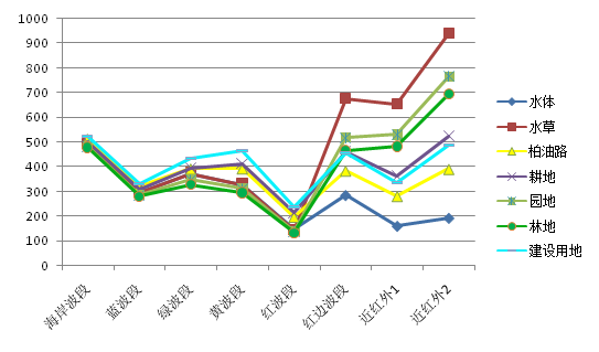
Figure 4. DN mean curves of study area around the material band
图4. 研究区各地物波段DN均值曲线图
由图4可知,各地物具有不同的光谱曲线,在WorldView-2影像各波段中,研究区各地物在波段7和波段8上的亮度值都较高。从总体上看,水草、建设用地、园地的DN值较高,水体及水利设施的亮度值较低。其中,在波段3和4上,建设用地的亮度值明显高于其他地物,在波段5上,林地的亮度值低于其他地物,在波段7和波段8上,水体的亮度值较低。因此,通过光谱信息可将大部分地物区分开来,但不能完全有效地区分,还需要借助除光谱特征之外的其他特征将各地物进行有效地区分。
4. 西安市临潼区WorldView-2八波段影像信息提取
4.1. 面向对象的用地类型信息提取
面向对象的影像分析技术采用多尺度分割技术生成有意义的多边形对象,以影像对象为信息提取的基本单元,运用模糊数学分类方法实现类别信息的自动提取[6] 。针对影像的局部异质性,面向对象的方法充分考虑像元与邻近像元的相互关系,从而有效克服“椒盐现象”,并能减少异物同谱和同物异谱的影响,所以,面向对象的方法能有效地克服传统方法的局限性,提高影像信息的提取精度[9] 。eCognition软件是第一个面向对象的遥感信息提取软件,本文研究内容是基于eCognition(Developer8.9)软件为平台,辅助其他遥感处理软件完成的。
面向对象分类方法:先是进行图像分割,分割效果与分割参数的设置息息相关,多尺度分割的主要参数包括:分割尺度、波段权重、匀质性因子(光滑度、紧致度)[10] 。考虑到本研究实验区的水体、农田、林地、建设用地等大的特征, 以及更详细的特征如柏油路、园地等需要更详细的分割。本文通过多次试验后设置分割尺度为60,形状因子0.1,紧致度和光滑度各为0.5,如图5所示,以能最大程度适合本研究区地物类型的提取。对于分割,目前没有适用于所有影像的通用算法,应结合实际情况与已有先验知识,使分割形成的对象既不太破碎,又能清晰表示地物类型边界[8] 。对分割后的影像建立合理的多层次分类体系,进而对研究区影像各地物进行特征计算和优化选择。
遥感地物信息提取的前提是建立在各地物类别特征基础上,因此,在分类前需要根据各地物特点,选择出最能表达该地物的特征或是特征组合。从不同角度选择地物的特征是非常重要的,这能从根本上找到各地物区别其他地类的特征[11] 。本文利用图4研究区各地物波段DN均值曲线图,并结合eCognition软件中所提供的丰富的光谱特征、几何特征、纹理特征、邻近关系特征等,针对每类地物都挑选出了最显著的分类特征。另外,分类的先后顺序是先从最容易提取的类别开始逐一提取,将无明显特征的地物放在最后一类。表1详细列出了本研究区各地物类别的分类特征及分类的先后顺序。图6至图12分别给出了每类地物的特征图,从每个图中都可以清晰地看出在此特征该地物类别与其他地物类别的显著差异。面向对象的分类结果如图13所示。
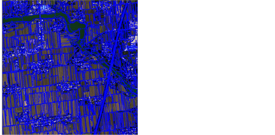
Figure 5. Segmentation result: scale: 60, shape = 0.1, smoothness = 0.5
图5. 尺度60,形状因子 = 0.1,光滑度0.5分割结果图
Table 1. Selected features of classification feature
表1. 研究区各地物分类特征选择
注释:①比值特征:给定波段对总体亮度的贡献值[12] 。②长宽比特征:对象的长度与宽度的比值[12] 。③标准方差特征:给定波段与组成对象的所有像素波段的明度值平均数的平方根[12] 。④Max.diff特征:最大差异特征[12] 。
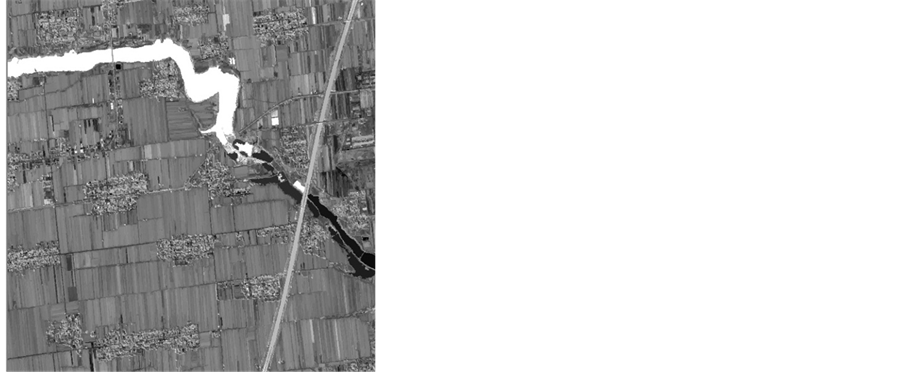
Figure 6. Ratio band 1 feature of water
图6. 水体在第1波段的比值特征
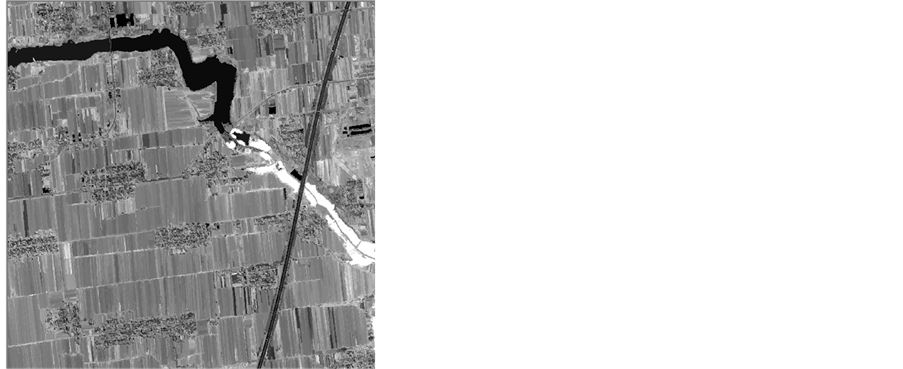
Figure 7. Ratio band 6 feature of water grass
图7. 水草在第6波段的比值特征
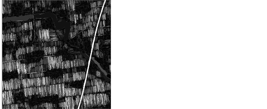
Figure 8. Length/width feature of asphalt road
图8. 柏油路的长宽比特征
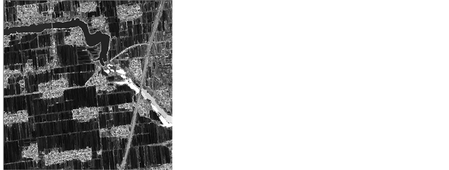
Figure 9. Standard deviation (8) feature of farmland
图9. 耕地在第8波段的标准差特征
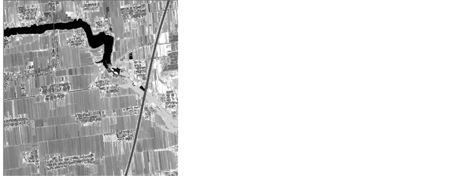
Figure 10. (Mean(6) + Mean(7) + Mean(8))/ Brightness feature of garden plot
图10. 园地在第6、7、8波段之和并与所有波段亮度值的比值特征
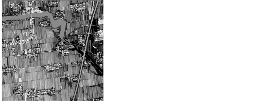
Figure 11. Ratio band 5 of forest
图11. 林地在第5波段的比值特征
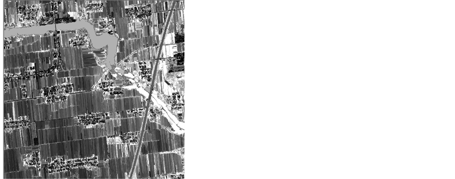
Figure 12. Max.diff feature of construction land
图12. 建设用地的亮度最大差异特征
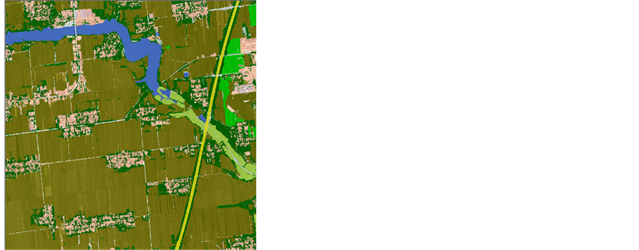
Figure 13. Object-oriented classification result of study area
图13. 研究区面向对象分类结果图
4.2. 面向像元的最大似然率分类
为了更加准确全面地反映面向对象的方法的优势,本文利用面向像元的最大似然分类方法对该实验区进行分类,其中类别样本与面向对象所用的类别样本类似,获得最佳的分类结果,并进行简单的分类后处理。最大似然法分类结果如图14所示。
4.3. 临潼地区耕地、水体等用地WorldView-2影像分类结果与分析
针对上述两种精确分类结果图像,采用基于图像信息综合评价方法[13] ,对以上两种分类方法的结果进行评价,通过混淆矩阵计算出分类的生产者精度、总体精度以及Kapppa系数。如表2和表3所示。
4.4. 两种分类方法对比分析
(1) 从表2和表3的对比可以明显地看出,面向对象分类法的分类精度要明显高于传统分类法,前者可以达到90%以上,而后者只有70%。这是因为面向对象分类在提取水体、水草、耕地、园地、林地等地物时,充分利用了WorldView-2丰富的光谱特征,而在提取耕地、柏油路、建设用地时,更多地利用
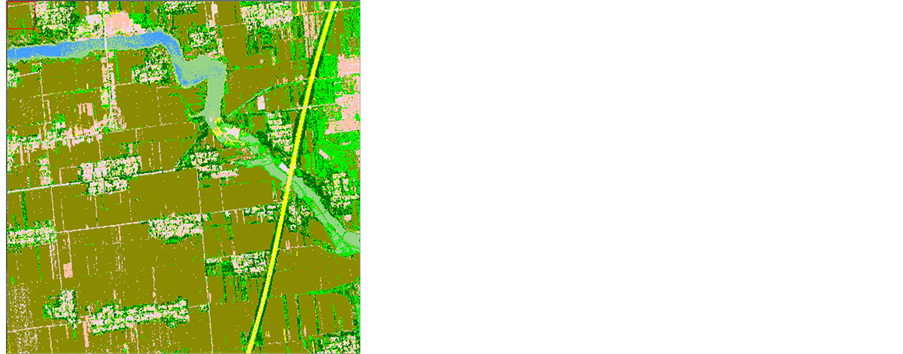
Figure 14. Maximum likelihood classification result of study area
图14. 研究区最大似然分类结果图
Table 2. Accuracy assessment statistic of the object-oriented classification
表2. 面向对象分类方法精度评价统计表
Table 3. Accuracy assessment statistic of Maximum likelihood classification
表3. 最大似然法分类结果精度评价统计表
了WorldView-2影像数据的几何特征、纹理特征等。而常规的分类方法仅利用光谱特征,导致建设用地与柏油路、林地与园地、林地与耕地等“同物异谱”及“异物同谱”的错分。从表1和图8、图9可以看出,足见,面向对象分类更能提高分类精度。
(2) 从图13和图14的对比可以看出,面向对象分类结果非常规整,地物形状清晰,利于后续应用。而常规分类方法的结果地物形状不清晰,“椒盐”现象明显,不利于地物形状提取。
5. 结论
(1) 本文充分分析了WorldView-2影像8个波段的光谱特征,研究基于WorldView-2影像的地物样本库,分析典型地物的光谱、纹理、几何等特征,提取耕地、水体、林地、园地、水草、道路、建设用地等典型地类,验证WorldView-2卫星8波段数据的信息提取精度能够达到90%以上。对WorldView-2影像在农田、水利及工程设施建设和国土资源、环境等行业,以及国家大型项目如地理国情监测的应用具有积极的推动意义。
(2) WorldView-2卫星8波段数据能表现出更真实、符合人类视觉欣赏习惯的色彩;能较客观地反映实地景观;影像上丰富的光谱特征、几何特征、纹理特征,能提供更多的细节,更全面地分析图像中的各种要素,更精确地提取地物类型,极大地拓展了影像数据应用范围,增强数据分类能力和提取地面目标能力。随着技术发展和研究的不断深入,WorldView-2在农田水利专题制图、土地利用与规划、资源开发与管理、环境保护与灾害监测、水利建设、农业林业等更多的应用领域会有很好的应用前景。
(3) 面向对象的分类方法能够充分利用WorldView-2八波段高分辨率影像丰富的光谱特征、几何特征和纹理特征以及对象间的关系特征,通过影像对象的特征组合建立最佳的分类规则,极大地提高了分类精度。这种方法能够有效克服传统的面向像元方法的局限性。因此,面向对象分类法是适于WorldView-2影像快速、自动、精确地识别高分辨率遥感数据的有效方法。