1. 引言
煤炭资源的大规模开采,破坏了上覆岩层的稳定性,导致地表的下沉、塌陷。由于地下采煤造成的地表塌陷,一方面造成地表建筑物裂缝甚至倒塌,也影响着当地农作物耕作条件。另一方面,矿区排水汇集成湖塘,对地表破坏污染成为矿区周围生产生活主要的污染源。如何有效监控避免地表形变造成的这些危害,提高塌陷报警应急反应能力,已成为目前亟待解决的问题。目前在矿区尺度上,常规方法(如地表形变测量)成本高,没有统一规范,更没有建立起一套可行的持续获取塌陷区监测数据的方法,对矿区生态环境演变问题尚无法提供充分的数据与技术的支持。
利用遥感技术进行塌陷区信息的提取是目前研究的方向,如07年汪宝存等利用TM数据和CBERS数据对开滦煤矿地面塌陷积水动态监测[1] ,杜培军等设计可靠的分类器和模型,用于采矿塌陷地的提取和识别等等[2] ,然而由于分辨率的限制,塌陷区信息的提取有一定的难度[3] ,主要表现在:遥感数据是二维数据,已有采用的遥感数据边界问题难以界定;塌陷区发生是个渐进的过程,难以表达高程变化的信息;塌陷区为积水体覆盖,其边界与非塌陷边界不统一;植被信息的难区分也是导致轻微塌陷区边界难以确定的一个方面[4] 。随着中高分辨率遥感数据的逐渐出现以及遥感技术与GIS的发展结合,解决以上问题成为了可能[5] 。本文就是利用遥感技术,主要利用SPOT纹理特性和高程DEM特征,以及采用数据的融合方法和多决策规则方法,将近二十年塌陷变化情况进行信息的提取,从而对引起生态环境全方位、立体化获得塌陷区变化的时空分布规律并适时做出预测工作。
2. 遥感数据源及塌陷区概况
2.1. 数据源
本次研究主要利用山东某矿区进行了塌陷区动态监测试验研究,采用的遥感数据包括遥感源Landsat TM/ETM+、SPOT;雷达数据;实测数据,DEM数据(表1)。

Table 1. The parameters of satellite image
表1. 卫星影像参数
本次试验主要采用两种不同数据源之间的融合,一是不同传感器及不同时相数据之间的融合;二是同一数据源不同时相数据之间的融合;实验关键技术要进行精确地空间配准。
本次空间配准包括1987年与2000年数据间的配准和SPOT数据与2000年数据间的配准。变化图与2013年塌陷区配准。
而影像的空间配准又可分为以下步骤[6] :
1) 特征选择:在即将配准的两幅遥感影像上,选择像边界、线状物交叉点、区域轮廓线等较为明显的特征。
2) 特征匹配:采用一些配准算法,找到两幅遥感影像上对应的相同地物点作为控制点。
3) 空间映射变化:根据找出的控制点,建立影像之间的映射关系。
4) 插值:再根据这样的映射关系,对非参考影像进行双线性内插重采样,得到和参考影像配准的影像。
遥感影像的空间配准精度一般在1~2个像元内。
2.2. 研究区概况
研究区位于鲁西,低山丘陵区,地势东北高西南低,暖温带半湿润季风气候。矿区东西长约22公里,南北宽约2~5公里,为石炭二叠纪全隐蔽煤田,总面积105.60平方公里。现有大封煤矿、杨庄煤矿等7个统配煤矿,年生产原煤650万吨左右,在煤炭资源开发过程中,引发的生态环境问题是多方面的,而对当地居民地表影响较大的就是塌陷区变化[7] 。
塌陷区影像特征成因:
1) 形成多条地面沉陷带
在遥感的影像上,采空塌陷区有大小不同的沉陷带或地裂缝,表现为线状地物,多为非人工所为。这些特征已经对地表造成很大破坏,实地验证发现:这些线状地物为使用陷落法管理顶板,由于地形突变引起了光谱差异,采空沉陷造成了微地貌陡坎或地面裂缝。采空沉陷区的类型有平行排列型、折线型和蠕虫型。规模较大的达宽数米,长数百米。
2) 呈水体塌陷
地面长期沉降而形成洼地、积水,再加上随开采深度增加和矿坑排水量的增大,水体面积就发生变化,通过不同时间遥感数据的对比,计算新增水域与原有水体的差异,这就是沉陷区变化的重要依据。此外,塌陷区地表水体形状为不规则状,有的复垦地为人工开挖的整齐湖塘的明显外形特征。主要分布在矿区附近,西部矿区特征更加明显。
3) 出现土地退化的迹象。
沉陷带或地裂缝使地下水渗漏,从而造成水位下降,形成新的土地退化,原有大片水浇地不得不改种其他作物,或是土地复垦后的类型,如杨树林地,灌木林等。在SPOT高分辨率图像上特征更加明显。分布区域多在开采区上方伴生。
4) 生态景观发生的改变
基于地面沉陷等原因,本来的地貌类型或植被类型发生了改变。像农田变成水体;耕地变成灌木、林地;麦田变成裸地。
综上所述,塌陷区变化主要以波谱特征高程变化为主,因此,本次研究拟利用数据融合(主成分分析)方法和决策树方法来提取这些变化的信息。
3. 数据融合原理及方法
图像数据融合是一个对多遥感器的图像数据和其它信息的处理过程。为突出塌陷区信息,着重于把那些在空间或时间上冗余或互补的多源数据,按主成分分析方法进行运算处理,以获得比任何单一数据更精确、更丰富的信息,生成一幅具有新的空间、波谱、时间特征的融合图像。
K-L变换是应用于遥感诸多领域的一种方法,在信息融合及变化监测等方面具有较强的优越性。K-L变换的本质是通过去除冗余,将有用的信息转入少数几幅影像(即前三个主成分),对大量影像进行概括和消除相关性。为了去除这些数据冗余,K-L变换采用相关系数阵或协方差阵来消除原始影像的相关性。相比于融合后的新图像,各波段的信息能最大限度地表现差异信息。
首先,本文利用两个时相(均为TM5,TM4,TM3)的六个波段经主成分变换融合,作PC1、PC2、PC3的合成,变换影像的主要变化信息以不同色调和纹理突现出来。
该方法能够实现简单快速获取变化图斑的效果,尤其是耕地被建设用地占用的区域,是以鲜艳的红色显示出来。
另一种融合是用新的时相的SPOT pan数据和前一时相的TM数据进行融合,该种方法是在两数据进行配准的基础上,首先对TM数据进行主成分分析,其次将SPOT与第一主成分直方图匹配,然后用匹配后的SPOT pan与其他主成分反变换,即可得到融合后的图像,该图像变化信息为特殊的色调和纹理显示出来。
除此以外,K-L变换的优点是能分离信息,减少数据冗余,从而突出不同的地物。而且K-L变换可以进行自动辐射校正,这样就无须再做相对辐射校正的处理。它不仅仅是数据间的简单复合,更强调信息的优化,以突出有用的专题信息,消除或抑制无关的信息,识别目标的具有更加清晰,从而增加解译的可靠性、减少模糊性、改善动态监测效果。
数据融合方案有以下两种:
1) 2000年ETM+与1987年TM的融合;
2) 2007年的SPOT pan波段与2000年ETM+波段的融合。
4. 实例分析
1) 2000年ETM+543波段与1987年TM543波段的融合
首先,将2000年ETM+543波段与87年TM543波段做直方图匹配增强,得到增强图像。
其次,将该两时相6波段的增强图像融合并进行PCA变换;
然后,得到如图(图1)所示的融合影像,影像中黄色图斑为变异图斑。
2) 2007年的SPOTpan波段与2000年ETM+波段543合成
首先,2007年分辨率为10米的PAN波段与2000年TM的PC1直方图匹配增强,得到增强图像。
其次,将上一步获得的增强图像替代2000年ETM+的PC1;
然后,再2000年ETM+的PC2,PC3合成,得到如图(图2)所示的融合影像,影像中蓝圈的淡蓝色图斑为变异图斑。为复垦后的塌陷区。
3) 动态变化分析
在GIS软件中,将影像融合图与提取后的图像建立在不同图层中,对照获取1987~2000年、2000~2007年间的塌陷区变换信息,如图(图3)所示,其中蓝色为1987年塌陷区,黄色部分为2000年塌陷区,红色部分为2007年塌陷区。最后利用GIS软件,将DEM数据套合变化监测图,修正塌陷区分布。
根据图3统计1987年、2000年、2007;为了获得最新塌陷信息,我们购买了2013年DEM数据,并通过GIS软件中,获得最近的年塌陷区面积(表2)。
在1987~2000年间塌陷区主要分布在矿区西部区域,塌陷区面积逐年增加较多,增加面积达到5.317 km2,塌陷区分布在煤矿的西南部,与整个矿区西南地势低有关(东北高,西南低),塌陷区没有太多复垦。说明开采重点主要在西部较新矿区;也说明西部煤层埋深大,需排水更多;2000年至2013年塌陷区变
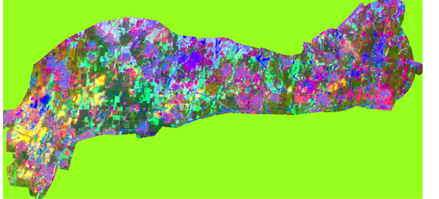
Figure 1. Date fusion of PC4, PC3, PC2
图1. 数据融合PC4,PC3,PC2合成

Figure 2. Fused image of SPOT pan and PC2, PC3
图2. SPOT pan与PC2、PC3的融合图像
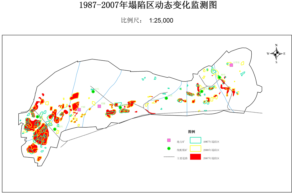
Figure 3. Change information map of collapse areas between 1987 and 2000
图3. 1987~2000年塌陷区变化信息图
Table 2. Area coverage of collapse areas
表2. 塌陷区覆盖面积
化较小,到2013年塌陷区总面积有72.8%复垦为鱼塘,新村等。
5. 结论
利用多源遥感数据融合方法进行塌陷区监测是可行的,即是,采用多时相主成分分析方法及数据融合方法能快速获取塌陷区变化信息,并获得如下方面的认识及结论:
1) 采用多源多时相主成分分析方法获取塌陷区变化信息的方法简单且快速;
2) 采用多源数据融合分析方法与GIS技术的结合方法获取塌陷区变化信息并制图;
3) 给出该矿区变化规律,1987年到2000年塌陷区变化较大,占总面积的60.123%,原因是期间采空区范围逐渐扩大,导致地表塌陷面积逐年增加;2000年到2007年塌陷区面积变化较小,到2007年塌陷区总面积有54.80%,减小的原因是大部分复垦为鱼塘,新村等。分析结果不仅为矿区生态环境评价和复垦提供基础数据,也为决策者制定相关措施提供技术支撑。
基金项目
山东省高校海洋测绘重点实验室(山东科技大学)资助项目(编号:2013B01)。