1. 绪论
在网络CORS测量与应用中,采用GPS接收机观测获得的是CGCS2000地心坐标系坐标,而我国长期连续性观测工程项目,采用的仍是BJ-54坐标系统,两类坐标不仅坐标原点不一致,而且相应的各坐标轴之间不平行,所以在实际应用中,必须进行坐标转换。
当测绘项目类似于长江这种狭长的带状工程,且距离过长时,项目仅统一求取一个转换参数时,其转换精度以及CORS测量作业的精度将会降低。本文以长江中游河道地形测量为例,详细论述带状测量中,基于网络CORS坐标系统下进行分区转换的方法,为类似工程测量提供参考。
2. 坐标系统转换
2.1. 坐标转换方法
坐标系统的转换[1] 包括同一椭球体之间和不同椭球体之间的转换两种方式,其转换的一些过程及方式见图1。
其中,基准转换的情况可能有以下几种:
1) 测区只有有限等级控制点的参心直角坐标系(X, Y, Z)。这种情况下,要根据实地情况标定地方坐标。
2) 测区已经有足够控制点的WGS84或CGCS2000坐标和地方坐标,并且有精确的相对位置关系。
3) 测区只有足够控制点的地方坐标,相对位置关系精确,但没有WGS84或CGCS2000坐标。这种情况下,可利用RTK测量方法。
坐标转换通常要满足下面几个条件:
1) 应有足够的控制点。一般地,平面控制至少三个;高程控制应根据地形地貌条件,控制点会更多(一般达到6个以上),以确保拟合精度要求。
2) 控制点的控制范围和分布的合理性。控制范围应以能够覆盖整个测区为原则。一般情况下,相邻控制点之间的距离在3 km~5 km,分布的合理性主要是指控制点分布的均匀性。
3) 控制点之间应具备相互位置关系精确的两套系统的坐标,以确保转换关系的正确性。
2.2. 坐标转换模型
坐标转换的模型多种多样。本文采用基于布尔莎模型的七参数转换方式[2] 。七参数法是两个椭球间的坐标
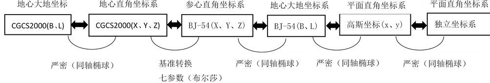
Figure 1. Process and method of coordinate transformation
图1. 坐标转换的过程及方式
转换,是一种较为严密的坐标转换。七参数法包括布尔莎模型,一步法模型,海尔曼特等,即X平移,Y平移,Z平移,X旋转,Y旋转,Z旋转,尺度变化比,七参数的控制范围较大(一般大于50 km2) [3] [4] ,求解七参数需要3个以上具有所需两种椭球下的两套已知坐标成果,且已知点组成的区域应在测区内均匀分布,能够覆盖整个测区,这样七参数的转换效果才会较好。布尔莎模型见公式1 [5] 。
 (1)
(1)
其中,m为尺度比参数; 为旋转参数;
 为平移参数。
2.3. 分区坐标转换
利用GPS进行带状工程测量,采用当地坐标系统时,根据测区跨度及测量精度的要求,需要对带状工程进行分区求取转换参数[6] ,分区时要注意以下几个问题:
1) 分区要以项目的地形高低起伏、转折以及公共点的分布情况等合理划分。保证公共点能控制整个测区。
2) 如果区域范围不大,测量区域最远点距离小于30 km (经验值),可以用三参数,即X平移,Y平移,Z平移,而将X旋转,Y旋转,Z旋转,尺度变化K视为0,所以三参数只是七参数的一种特例。
3) 局部区域坐标转换采用七参数法比较合适,带状工程一般按照50 km进行分区即可满足大比例尺测图的需求,范围较大时可采用多项式回归模型以提高转换精度。
4) 采用分区求解转换参数时,相邻分区应不少于2个重合点,并进行精度统计估算。
3. 项目实例
3.1. 项目实施
长江中游荆江河段宜昌至监利河段全长约300 km,经度从111˚带横跨到114˚带,整个测量区域由西向东呈条带状分布。测区处于HBCORS覆盖的地带,为了更好利用其网络RTK的便捷资源,整个测区在HBCORS系统下建立了首级控制网,共有110个控制点。首级分两个带平差,得到SGCS2000及BJ-54两套坐标系统成果。
测区属于长期连续性观测项目,考虑到湖北CORS系统观测的便捷性及资料的连续性,对测区进行分区,求解坐标转换参数。本项目沿河道走向及点位布置划分成若干个区域,每个区域长约50 km左右,相邻区域有一定的公共点重合,来求解每个测区的转换参数。其中的5个部分分区区号及点号组合见表1。
部分河段的分区划分情况见图2所示(因资料的保密性,所以点名及图形均作了处理)。
进行测区转换参数求解后,得到各公共点转换的残差,其平面的最大值为0.09 m,高程转换残差最大值为0.44 m,精度可以满足大比例尺测图的要求。其残差发布如图3,图4所示。

Table 1. Part of the area and point combination for coordinate transformation
表1. 部分坐标转换分区区号及点号组合
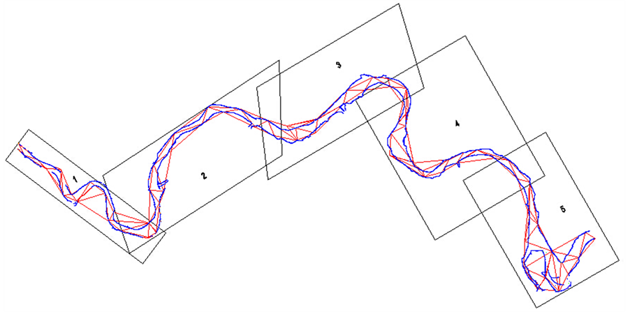
Figure 2. District level schematic diagram of the river
图2. 部分河段的分区划分示意图
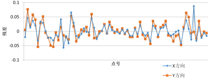
Figure 3. Plane transformation residual chart
图3. 平面转换残差图
3.2. 精度分析
3.2.1. 同一分区公共点数量及发布对转换参数的影响分析
选择其中的一个分区进行不同数量的公共点参与坐标转换,对比情况见表2 所示。
对比可知,公共点个数的多少对于转换精度影响不是很大,但是公共点的分布要能控制整个测区,点位分布均匀为宜。
3.2.2. 分区大小的精度影响分析
把其中的一个长约40 km的分区再划分成两个20 km的小分区,其对比情况见表3所示。
表3对比可知,分区较小时比分区较大时其平面的转换精有较大的提高,而高程精度提高不大,这主要与高程异常分布、GPS本身大地高精度等因素有关。
3.2.3. 相邻分区准换的精度估算
进行坐标分区转换后,相邻分区公共点的精度是通过求取转换参数的重合点的残差中误差体现的,精度依据式2计算,其中通过残差v的取值不同主要计算不同的精度。
 (2)
(2)
1) 公共点互差检查,将上述5个相邻分区的12个公共点的CGCS2000坐标利用两个区的七参数将其转换
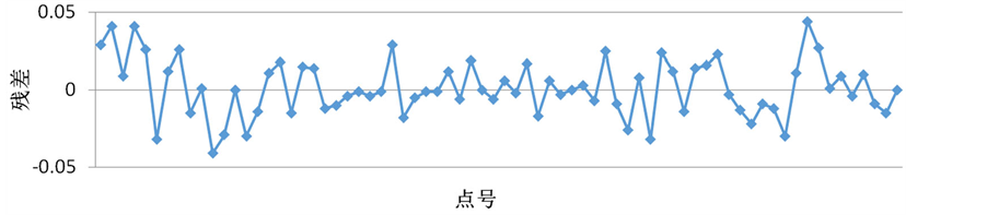
Figure 4. Elevation transformation residual chart
图4. 高程转换残差图
Table 2. Different numbers of common points in the residual distribution of coordinate transformation
表2. 不同数量的公共点参与坐标转换的残差分布
Table 3. Conversion residuals distribution for different partitions
表3. 大小不同的分区转换残差分布情况
Table 4. Seven-parameter conversion point coordinate mutual difference statistics
表4. 利用七参数转换求得的网点坐标互差统计表(m)
Table 5. Seven-parameter conversion point with the known coordinates poor statistics
表5. 利用七参数转换求得的网点坐标与已知点坐标较差统计表(m)
为BJ-54坐标下的坐标进行比较,计算残差v,得到相邻分区公共点精度见表4,并利用中误差计算公式(2)分区域分方向进行统计(表2)。
2) 公共点精度较差,将上述5个相邻分区公共点的CGCS2000坐标利用不同分区的七参数将其转换为BJ-54坐标,共计24点,与已知的坐标进行比较,计算残差v,得到公共点精度,如表5。
经过多次对比及试验结果分析,当公共点满足以下条件时计算精度较高:① 相邻分区重叠重合点分布在分区边界线周围。② 公共点分布要均匀,分布范围要广,构成网形能控制整个转换区域。③ 在公共点分布均匀的情况下适当增加公共点的个数。
4. 结论
通过对SGCS000与BJ-54分区坐标转换方法的分析,结合工程项目对结果影响的比较,可得出以下结论。
1) 在坐标转换参数计算中,要保证公共点的分布、精度及分区大小等。
2) 当测区范围较小时(最远点小于30 km),可采用三参数转换。七参数转换则控制范围较大,一般大于50 km2 [1] 。如果精度要求较高,最好分区进行转换。如大连市C级GPS网覆盖面积为17,000 km2,采用七参数的转换精度高于三参数的转换精度,且将全网分成4部分进行七参数坐标转换,转换误差将缩小2倍,转换精度可达厘米级[2] 。
3) 在较大测区范围内,且测绘项目主要集中在该区域的情况下,应利用已有成果或坐标联测等方式,获得能够控制该测区的两套坐标,进行7参数求定。从而避免小测区4参数坐标校正,更换测区要重新计算等繁琐工作。可节省大量的人力、物力,大大提高工作效率。
4) 当进行两种不同空间直角坐标转换时,坐标转换的精度除取决于坐标变换的数学模型和求解参数的公共点坐标精度外,还和公共点多少、几何形状结构有关。鉴于地面网可能存在一定的系统误差,且不同区域并非完全一样,所以采用分区变换参数,利用布尔莎模型分区进行坐标转换,可明显提高坐标转换精度。