1. 引言
地质灾害是自然灾害的一种,是在地质作用下,地质自然环境恶化,造成人类生命财产损毁或人类赖以生存和发展的资源、环境发生严重破坏的现象或过程 [1] 。地质灾害的发育与危害程度除受地形地貌、地质构造、地层岩性、岩土体结构等地质环境条件控制外,还与地震、降雨、人类经济工程活动等诱发因素密切相关 [2] 。我国是世界上地质灾害危害最严重的国家之一,地质灾害已严重制约着国民经济的发展,威胁着人民的生命和财产安全,成为影响我国社会经济可持续发展的重要制约因素 [3] 。地质灾害危险性评价作为一种重要的防灾减灾非工程措施,可以为地质灾害防治规划提供依据,对于减轻和预防地质灾害具有重要意义,为此,国内外学者开展了大量的研究,取得了一系列研究成果 [4] - [10] 。如:1981年美国学者Hollingdworth and Kovacs将坡度、岩性、切割密度3个评价因子总共划分为5个等级(0,1,2,3,4),再通过叠加法进行了泥石流危险度的评价 [11] 。朱静和唐川采用地形指标(相对高差)、岩性指标(软化系数)、地质构造指标(断裂类型)等八大评价指标对云南省泥石流灾害的危险性进行了分区 [12] 。唐红梅等以重庆市万州区为例,选择7个评价因子,采用综合评价法获取危险性指数,并进行了地质灾害危险性分区 [13] 。
综合分析,地质灾害危险性评价经历了由早期的定性或半定量评价到现在的定量化、模型化操作的发展历程。上世纪90年代以来,随着计算机和GIS技术的广泛应用,极大地提高了地质灾害资料的获取、分析及计算能力,可以直观地将分析计算结果以图件的形式表现出来,使地质灾害危险性评价产生了质的飞跃。但是,由于涉及因子众多,而且许多因素具有很大的人为性和不确定性,所以迄今为止仍是当今世界正在努力探索,而悬而未决,甚至存严重分歧的问题 [14] 。
为此,本文采用本底因子贡献率模型进行地质灾害危险性分析。以南宁市主要地质灾害为研究对象,基于GIS平台,首先构建地质灾害危险性评价指标体系,利用本底因子贡献率模型确定各评价因子的自权重和互权重;其次,建立地质灾害危险性综合评价模型,计算得到各网格地质灾害危险性综合指数值,最后,通过自然临近插值等方法进行地质灾害危险性分析,为南宁地质灾害防灾减灾提供依据。
2. 研究区概况
南宁地处西南边陲,介于东经107˚45'~180˚51',北纬22˚12'~23˚31'之间,地理位置如图1。地势大致呈西北、西南略高,向东倾斜。南宁市地貌以侵蚀堆积邕江河谷阶地貌和侵蚀、剥蚀丘陵区地貌为主,主要为平地、台地、丘陵、石山、低山、中山等。南宁市位于华南褶皱带右江再生地槽南缘的西大明山隆起带内,区域地质构造断裂发育,地层以泥盆纪灰岩、砂岩、页岩和石炭纪、二迭纪灰岩及三迭纪砂
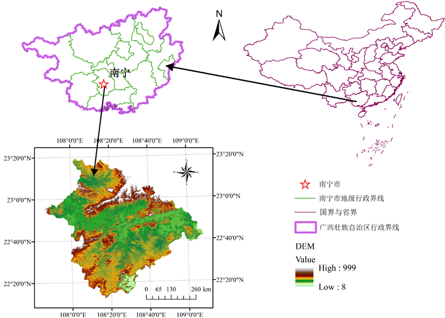
Figure 1. The location of the study area
图1. 研究区地理位置示意图
岩和页岩为主 [15] 。
南宁市是地质灾害较为频发的地区之一,具有种类多,分布面广、相对集中、稳定性较差等特点,主要有滑坡、崩塌、不稳定斜坡、地面塌陷、地裂缝等5种,其中以滑坡、崩塌最为常见。截止2010年8月,全市发现有各类地质灾害点及隐患点共119处,已发生地质灾害116处,造成1人受伤,92间民房遭毁(破)坏,直接经济损失达567.7万元 [16] 。
3. 地质灾害危险性评价指标体系构建
根据南宁市地质灾害发育特征和区域地质条件,结合数据的可获取性,借鉴前人相关研究成果,经过专家讨论和综合研判,选择南宁市地层岩性、高程、坡度、坡向、植被覆盖指数NDVI和土地利用6大因子,构建地质灾害危险性评价指标体系。
3.1. 地层岩性
采用全国1:250万电子地质图及说明材料,通过GIS软件提取南宁市的主要地层岩性,将其分为9大类参与地质灾害的危险性分析,如图2(a)。
3.2. 地形坡度
坡度表示局部地表坡面的倾斜程度,其大小直接影响着地表物质流动与能量转换的规模与强度。采
用南宁市DEM,通过GIS空间分析功能提取坡度。南宁市地形坡度在0~72.3542°之间(图2(b)),按10˚为一级将南宁市域坡度划分为0˚~10˚、10˚~20˚、20˚~30˚、30˚~40˚、40˚~50˚、50˚~60˚和大于60˚共7个属性,参与地质灾害的危险性分析。
3.3. 高程
高程不仅决定着地表水热条件和人类活动所能到达的范围,而且代表者重力势能的大小,为地质灾害提供能量条件。由南宁市DEM可知,南宁市高程在8~999 m(图2(c)),利用GIS空间分析功能,按100 m的区间将高程划分为8~100 m、100~200 m、200~300 m、300~400 m、400~500 m、500~600 m、600~700 m、700~80 0 m、800~900 m和大于900 m共10个属性,参与地质灾害的危险性分析。
3.4. 坡向
不同斜坡坡向的太阳辐射强度等条件不同,影响了水蒸发量、植被覆盖、坡面侵蚀等诸多因素,从而影响了斜坡的地下水孔隙压力的分布及岩土体物理力学特征,因而影响斜坡的稳定。利用南宁市DEM,通过GIS空间分析功能提取坡向,将其分为平地(−1)、北(0˚~22.5˚, 337.5˚~360˚)、东北(22.5˚~67.5˚)、东(67.5˚~112.5˚)、东南(112.5˚~157.5˚)、南(157.5˚~202.5˚)、西南(202.5˚~247.5˚)、西(247.5˚~292.5˚)、西北(292.5˚~337.5˚)共9个属性(图2(d)),参与地质灾害的危险性分析。
3.5. 植被覆盖指数NDVI
NDVI反映植物冠层的影响,负值表示地面覆盖为云、水、雪等,对可见光高反射;0表示有岩石或裸土等;正值,表示有植被覆盖,且随覆盖度增大而增大。采用2013年Landsat 8 遥感影像,提取NDVI,南宁市NDVI在−1~0.552479之间(图2(e)),将其划分为极低覆盖度(NDVI < 0.1)、低覆盖度(0.1 ≤ NDVI < 0.3)、中覆盖度(0.3 ≤ NDVI < 0.5)和高覆盖度(NDVI ≥ 0.5)共4个属性,参与地质灾害的危险性分析。
3.6. 土地利用
土地利用代表了人类活动的程度。采用2013年Landsat 8遥感影像,在ENVI中用监督分类法进行土地利用分类,将南宁市土地利用类型划分为水体、林地、裸地、农用地和建设用地共5大类(图2(f)),参与地质灾害的危险性分析。
4. 地质灾害危险性评价模型
基于GIS平台,首先对评价因子进行统一栅格化处理,假设评价指标因子为一个数集:
 (1)
(1)
式中, 为因子数集,
 为关系式,
为关系式, 为指标因子(
 -地层岩性,
 为地形坡度…)。
参加危险性评估的每一个评价因子指标对地质灾害发育作出不同程度的贡献,检验贡献程度的大小需要建立基本量化标准。在可靠的地质灾害数据基础上,拟选用量密度、面密度、体密度三项量化检验指标进行贡献程度评价,即:
 (2)
(2)
式中, 为因子贡献率评价式,
 为检验指标,其中,
 为量密度指标(
 ,
, 为各评价因子中地质灾害数量,
 为研究区地质灾害总数量),
 为面密度指标(
 ,
, 为评价因子中地质灾害面积,
 为研究区地质灾害总面积),
 为体密度指标(
 ,
, 为评价因子中地质灾害体积,
 为研究区地质灾害总体积)。由于本研究的地质灾害数据资料中不具备
 和
和 的条件,所以此次选用的量化检验指标只有
 一项。
一项。
4.1. 因子贡献率指数和贡献率
贡献率指数是评价因子对地质灾害危险性贡献程度的重要指标之一,如下式:
 (3)
(3)
式中, 为因子贡献指数,
 为各评价因子子集内的地质灾害数,
 为各评价因子的总地质灾害数。
贡献率通过贡献率指数进行计算,表达式如下式:
 (4)
(4)
式中, 为因子
为因子 中第
中第 个评价因子的贡献率,
 为评价因子的贡献率指数之和。
4.2. 权重转换模型
各评价因子内部的自权重计算公式为:
 (5)
(5)
式中, 为地质灾害评价因子
 的自权重,
的自权重, 为因子
为因子 中第
中第 个评价因子的贡献率。
各评价因子的互权重通过下式计算:
 (6)
(6)
式中, 为地质灾害评价因子
 的互权重,
的互权重, 为各评价因子的综合贡献率,
 。
。
4.3. 地质灾害危险性综合评价模型
对各个评价因子的自权重和互权重相乘并进行叠加,得到南宁市地质灾害危险性评价模型:
 (7)
(7)
式中, 为地质灾害危险性综合指数,
 为地质灾害评价因子
 的自权重,
的自权重, 为地质灾害评价因子
 的互权重,
的互权重, 为各地质灾害评价因子的贡献指数。
整个计算体系如图3所示。
5. 计算结果
5.1. 各评价因子的贡献率指数、贡献率及权重计算
以GIS为平台,对地质灾害危险分区指标体系的各个评价因子子集中的地质灾害个数进行统计,并按式(3)、式(4)、式(5)和式(6)对各个评价因子的贡献率指数、贡献率、自权重和互权重分别进行计算,计算结果如表1所示。
由表1可以看出,南宁市对地质灾害发育程度贡献率高的地层岩性为第四系、石炭纪和白垩纪地层,贡献指数分别为22.69%、16.81%和15.97%,贡献指数之和占了55.46%;地质灾害大多发生在坡度20˚和高程200 m的范围内,贡献指数分别占了86.55%和82.35%,这个范围主要是人类活动的范围,人为诱发的地质灾害数目多;坡向贡献率较高的为西南和南坡,贡献指数分别为18.49%和17.65%;植被覆盖NDVI中低覆盖度对地质灾害的贡献指数最高,达到了60.50%,说明高覆盖度和裸地对地质灾害的发育不明显;土地利用指标中林地和建设用地对地质灾害的贡献率较高,贡献指数分别为33.61%和32.78%。
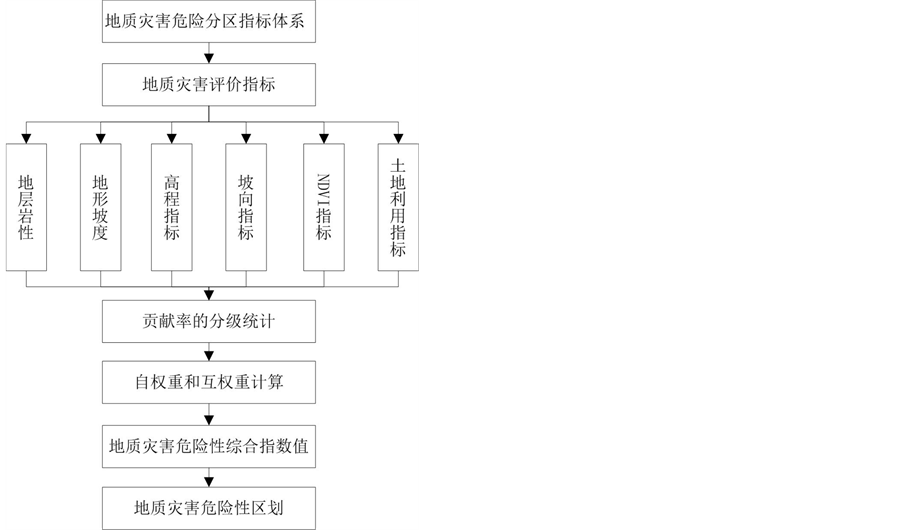
Figure 3. The calculated flow chart of the model
图3. 模型计算流程示意图

Table 1. The statistical table of contribution indexes, contribution rates and weights of each factors in the study area
表1. 研究区各个评价因子的贡献指数、贡献率和权重的统计分析表
续表
5.2. 南宁市地质灾害危险性评价分析
在GIS软件中,各个评价因子按上表的因子分级进行重分类,并分别增加贡献指数和自权重属性表,将计算的贡献指数和自权重分别导入到各评价因子属性表,然后按式(7)进行地质灾害危险性综合指数的计算。由计算结果可知,南宁市地质灾害危险性综合指数分布在1.18368~19.8259之间,根据该值对南宁市连续空间上的地质灾害危险度区划进行分区,得到5个划分区间:安全区,低危险度区、中危险度区,较高危险度区和高危险度区,如图4所示。
利用南宁市的119个灾害点对划分结果进行检验。从密度分布(每平方公里内滑坡泥石流地质灾害点的个数)曲线(图5)上可以看出,从安全区到高危险度区,灾害点的分布密度逐渐增高,评价结果基本合理。
分析结果显示:高度危险区主要分布在南宁市中部,包括蒲庙、沙井、那洪、良庆镇、琅东、三塘、五塘等地区,该区人类工程活动强烈,城区建设、道路修建进行削坡切坡、建设用地开发大量堆填土弃土,形成松散的高陡人工边坡,是地质灾害高危险区;该区以丘陵地貌为主,高程在200 m以内,面积约为5274.189 km2,占全市总面积的6.84%。较高危险区主要分布在南宁市南部、东南部地区,包括那楼、百济、那陈、西大明山等地,地形坡度在10˚~45˚、高程在200 m以内,以低山、丘陵为主,面积约为9859.604 km2,占12.79%。中危险区主要分布在南宁市西南部、北部地区,包括苏圩、吴圩、延安、武鸣双桥、宁武镇等地,地貌类型包括低山丘陵、平原及河流阶地为主,面积约为12358.724 km2,占16.04%。
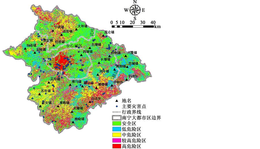
Figure 4. The analyzed result of geological hazard in Nanning city
图4. 南宁市地质灾害危险性分析结果图
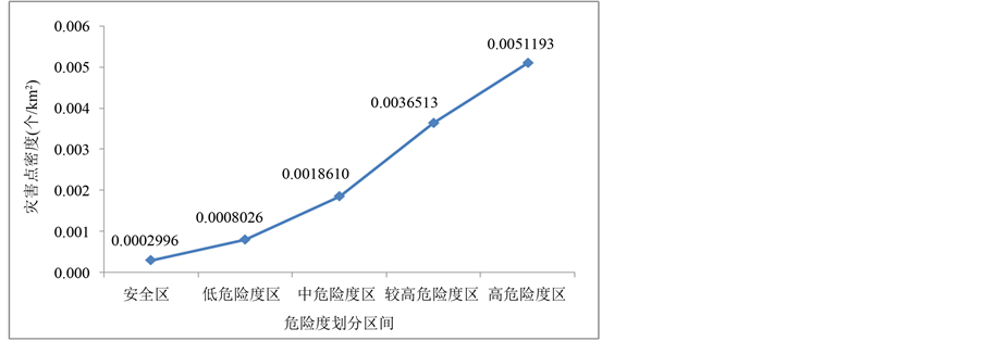
Figure 5. The distribution of geological hazards density in each hazard level
图5. 每个危险度级别中地质灾害密度分布图
低危险区主要分布在南宁市东部,包括南阳、峦城、金陵、坛洛等镇,以农用地为主,坡度和高程较小,面积约为16198.205 km2,占21.02%;安全区面积较大,分布在市境内的西部、北部和东北部,面积33379.713 km2,占全市总面积的43.31%。
6. 结论
1) 通过对南宁市主要地质灾害发育特征和环境背景条件的综合研判,确定了影响南宁市地质灾害危险性的6大关键因子,即地层岩性、高程、坡度、坡向、植被覆盖指数NDVI和土地利用,并构建了地质灾害危险性评价指标体系。
2) 基于GIS平台,对各个评价因子对地质灾害的贡献指数和贡献率进行了计算和分析,得到了对地质灾害发育程度贡献率高的评价指标范围。
3) 根据贡献率权重叠加模型,建立了地质灾害危险性综合评价模型,并计算了各网格地质灾害危险性综合指数,其分布在1.18368~19.8259之间。
4) 根据地质灾害危险性综合指数值,将南宁市地质灾害危险度区划分为5个区间:安全区,低危险度区、中危险度区,较高危险度区和高危险度区;并利用南宁市的119个灾害点对划分结果进行检验,评价结果基本合理。高度危险区主要分布在中部,人类活动强烈,面积约为5274.189 km2,占总面积的6.84%;较高危险区在南宁市南部、东南部地区,面积约为9859.604 km2,占12.79%;中危险区主要分布在南宁市西南部、北部地区,面积约为12358.724 km2,占16.04%;低危险区主要分布在南宁市东部,面积约为16198.205 km2,占21.02%;安全区面积较大,约为33379.713 km2,占全市总面积的43.31%。
基金项目
广东省水利科技创新项目(2016-15)和广东省科技计划项目(2013B031500007, 2014A020219006, 2014A020218013)联合资助。