摘要:
本文基于GIS空间分析技术进行流域信息分析,结合坡度、地形起伏度等地形特征,利用逆流原理对湖南省山洪沟边界信息进行提取,结果表明:1) 湖南省山洪沟多分布在湖南省西北部、南部和中部山区。与降水分布进行对比,发现这些地区降水分布相对集中,且出现强降水的概率较大,出现山洪灾害的风险较高。2) 对山洪沟预测指标进行等级分级,用不同等级值反映了山洪灾害发生的概率,可以看出提取的山洪沟位置信息与实际发生山洪灾害的位置有很好的对应关系。说明山洪沟的分布能在一定程度内反映出山洪灾害的发生地点。3) GIS提取结果与历史普查的山洪灾害发生区域进行叠加分析,相似度较高,较好的验证了山洪沟提取的可靠性。
Abstract:
In this paper, GIS spatial analysis technique is based on watershed information analysis, combined with slope, terrain ruggedness, and other terrain features, to extract flash floods ditch of Hunan. The results showed that: 1) Flash floods ditches are located in mountainous areas of northwestern, southern and central in Hunan Province. Compared with the distribution of precipitation, rainfall distribution is concentrated in these areas, and both the probability of heavy precipitation and risk of flood disasters are higher. 2) Used different levels of value to reflect the probability of flash floods disasters, we can see that it has a good relationship between flash flood position by extracted and the actual location of flood disasters. To some extent, the distribution of flash floods ditch also has been reflected the occurrence of flood disasters in place. 3) The results can reflect the Flash floods ditch extraction reliability compared with the history fact of flash flood disasters.
1. 引言
坡沟系统是由沟间地与沟谷地及各种环境要素所构成的、具有独特结构与功能的区域空间综合体 [1] 。山区内的任一沟道小流域,沟间地与沟谷地以及各种微地貌也呈现有序的垂直方向分布,区域所发生的各种土壤侵蚀现象都具有相似的分布规律。
山洪主要源于这类坡沟系统,当遇到强降水发生时往往会引起坡沟见洪水暴涨,从而引发山洪灾害 [2] 。山洪灾害主要发生在强降水后的一段时间内,影响地区主要集中在河道或其两侧,根据山洪灾害的特点,主要影响因素为地形高差、河网密度、强降水气候特征、流域平均面雨量极值等。
山洪灾害的形成受地形地貌、水文、气象、人为等众多因素的影响。鉴于各种地质因素之间相互作用的复杂性以及所收集到的资料和研究的效率与准确,本研究尽可能全的收集到各种灾害性因素的数据,包括高程、坡度、坡向、流量、流域、和网密度、降雨量、山洪灾害的历史发生情况等 [3] [4] ,以便于筛选山洪灾害的坡沟系统的形状和分布的指标。
本文利用GIS空间分析技术,结合地理地质数据和气象水文气候特征数据,对湖南省的山洪沟空间分布进行提取,并以此为依据山洪地质灾害防治精细化预报服务,从而为湖南省中小河流洪水、山洪地质灾害预警系统业务提供有效的科技支撑,并为气象应急服务提供参考。
2. 数据
2.1. 数据来源
本文的气象数据主要利用2008~2014年湖南省自动气象站的分时数据,地形数据利用分辨率为25 m的湖南省数字高程模型(DEM)数据。通过计算自动雨量站最大1 h、3 h、6 h降雨量数据,将数据格点化后插值到全省用于山洪风险计算,同时利用DEM数据计算出坡度、高程、地表起伏度、河流水系等用于流域的获取和坡道的提取。
2.2. 数据预处理
DEM数据在获得过程由于人为或非人为因素会造成数据局部信息的错误或失真,所以数据预处理是保证数字流域构建顺利进行的重要环节。对于有数据缺失的部分补齐,方法可以使用周围相似高程插值的来处理,或者将其直接复制为周围想进高程点的数值,处理过程相对容易操作。而洼地填充也是DEM数据预处理的不可忽略的一步。洼地填充的方法目前有几种,本文主要采用常用的高程增量叠加法 [5] ,通过对洼地栅格的高程进行增高处理,使得DEM中洼地栅格的高程值与周围栅格中最小高程值一致,然后进行纠正处理,便可获取到无洼地DEM数据。但是,洼地是要与真实的水域分别开的,合适的阈值对填充效果有很大影响。本文对湖南省域内的DEM进行循环填挖处理,直至洼地完全填平。
3. 山洪沟信息提取方法
数字河网生成是构成流域水系的基础,也是山洪沟提取的前期条件。根据山洪形成的原理可知,山洪灾害主要发生在强降水后的一段时间内,影响地区主要集中在河道或其两侧,在提取山洪沟之前首先进行数字河网提取。然后对降水数据与地形数据进行综合叠加,以确定强降水发生时山洪形成的区域。山洪沟提取主要步骤:1) 提取水流方向;2) 计算汇流累积量;3) 提取河网;4) 划分流域;5) 细分子流域;6) 叠加地形数据与降水数据;7) 山洪沟提取(如图1所示)。
本文基于TOPAZ算法来实现流域水系的构建,基本建立思路是地表产汇流分析、数字化河网的构建、流域的划分。利用水文分析方法将水流划分为8个方向,根据水流有地势较高的地方向地势低的地方流动的原理,在一个计算单元内计算出相邻单元格中高程最小值,可以将其确定为水流的方向,依次循环;对出现洼地的区域采用高程增量叠加填平来处理断流的问题,从而形成合理的汇流区域。将所得流域划分为若干个小单元,确定单元出水口特征,对每个小单元进行地形因子的加权叠加运算,综合水流和地形因素,对综合权值较高的区域进行细分提取,即可确定山洪沟的形状和区域。
利用GIS的水分分析工具对湖南省DEM数据进行建模,对原始DEM数据进行循环填挖,去除其中产生断流的信息,计算汇流信息并建立栅格河网,在实际水流分析过程中,利用设置的阈值与水系的调查资料进行比较,将水流阈值设置为20K,较符合实际情况。利用计算的汇流信息与和河网信息直接可生成河流的分水岭,可直接视为流域的信息。通过对比实际流域地表径流信息,将全省流域按水系划分湘江、资江、沅水、澧水、洞庭湖五大流域,对各大支流按流域面积大小细分为124个子流域(图略)。利用根据栅格河网的密度分布计算结果,按照流域边界信息做进一步细分,划定小单元格的分水岭界限。根据山洪形成的特点,将降水信息叠加到地形数据之中,计算坡度、地形起伏度以及降水对山洪汇流的影响因子,计算山洪形成的风险,将风险较高的区域与子流域的分水岭信息进行匹配计算,对形成的子单元格根据山洪沟的特点和筛选原则进行筛选,提取相应山洪沟的信息。
4. 山洪沟提取结果分析
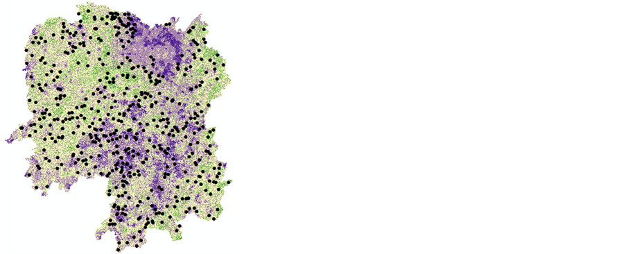
图2中展现了山洪沟提取信息的统计结果,湖南省范围内共提取469条山洪沟信息,且分布多集中在湖南省西北部、南部和中部山区;从降水分布来看(图3),湖南省的降水分布表现出北多南少的整体趋势,降水指数较高的区域向西、南、东部山地集中;降水综合指数较高的区域产生短历时强降水的概率也相应偏高,山洪的爆发也主要源自于短历时的强降水 [6] 。对比提取的山洪沟分布区域,在这些地区降水分布较为集中,且出现强降水的概率较大,出现山洪灾害的风险较高。
对山洪预测指标进行分级,用不同等级值反映了山洪灾害发生的概率,等级值越高说明其发生山洪灾害的概率越大。根据重分类之后得到的各因子权重加权值,将危险等级按照综合权重将最终结果分为5级。图4是有确切记录的历史调查中出现山洪灾害的位置与模拟的结果对比,结合图2结果可知,提取的山洪沟位置信息与实际发生山洪灾害的位置有很好的对应关系。这说明基于GIS技术的山洪沟提取方法能在一定程度内反映出山洪灾害的发生地点,相对于过去那种以行政区域为单位的划分划分方法,
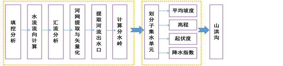
Figure 1. Process of flash flood ditch extraction based on DEM in Hunan Province
图1. 基于数字高程模型(DEM)的湖南省山洪沟提取技术流程

Figure 2. Distribution of flash flood ditch in Hunan province
图2. 湖南省提取的山洪沟分布图

Figure 3. Distribution of rainfall composite index of Hunan province
图3. 湖南省降水综合指数


 (a) (b)
Figure 4. Distribution of flash flood disasters (a) and history fact offlash flood disasters (b)
图4. 山洪灾害空间分布(a)与历史实况山洪灾害分布(b)图
提高了准确性。同时也对于一些调查资料缺乏的地区发生山洪灾害的可能性也作出技术上的补充。
5. 小结
本文使用2008-2014年湖南省自动气象站的分时数据和分辨率为25 m的湖南省数字高程模型(DEM)数据,利用GIS空间分析技术在分析数字流域信息的基础上,结合坡度、地形起伏度、等地形特征,利用逆流原理对湖南省山洪沟边界信息进行提取,结果表明:
1) 湖南省山洪沟多分布在湖南省西北部、南部和中部山区。与降水分布进行对比,发现这些地区降水分布将为集中,且出现强降水的概率较大,出现山洪灾害的风险较高。
2) 对山洪沟预测指标进行等级分级,用不同等级值反映了山洪灾害发生的概率,可以看出提取的山洪沟位置信息与实际发生山洪灾害的位置有很好的对应关系。说明山洪沟的分布能在一定程度内反映出山洪灾害的发生地点。
3) 对于无资料或者难以获取资料地区的可以对属性接近或相同的地区运用相似法获取准确的山洪沟信息,从而对调查资料不足地区进行补充,同时为面雨量计算提供了基础信息。
基金项目
湖南省气象局精细化要素创新团队。