1. 引言
天然草原不仅是畜牧业的基础和广大牧民的基本生产生活资料,而且是陆地生态系统的重要组成部分。近年来,天然草原由于受气候变化、自然灾害(鼠害、虫害、雪灾、毒杂草危害)等因素的影响,加之过度放牧等人为因素,90%以上的天然草原出现了不同程度的退化。为全面保护与恢复天然草原,近年来国家相继实施和出台了退耕还草、天然草原植被恢复与建设、退牧还草、草原生态保护补助奖励机制等草原生态建设重大工程与保护政策,急需对这些重大工程的进展情况及效益进行及时准确的监测与评价,为各级政府部门决策和合理利用草原资源提供科学依据。
随着草原生态建设工程规模的不断扩大,利用3S技术,即遥感(RS)、地理信息系统(GIS)和全球定位系统(GPS手持终端),对各类工程进行动态监测和科学管理,快速、全面、系统地掌握工程建设状况等信息,对工程实施效益进行综合评价,指导进一步做好工程建设项目的合理规划,为国家农业生产建设规划和宏观政策的制定提供依据。四川省若尔盖县2003以年以来实施了国家天然草原退牧还草工程建设项目,为及时掌握该项目的实施进度、工程建设完成情况、实施效益情况,利用3S技术对该县2003~2010年度以来实施的退牧还草工程效益进行了长期监测,分析、评价退牧还草工程建设的综合效益及草原生态现状。
2. 研究区概况
2.1. 全县基本情况
若尔盖县位于四川省西北部和阿坝藏族羌族自治州北部,地处青藏高原东北边缘。地理坐标为东径102˚08'~103˚39',北纬32˚56'~39˚19'之间,县境东西长、南北宽均约110公里,居川、甘、青三省交界处。全县总土地面积1565.4万亩,其中天然草地面积1212.63万亩,占总面积的77.64%,可利用草地面积978万亩,占草地总面积的80.65%,是川西北牧区的重要组成部份,四川省十个纯牧业县之一。牧区平均海拔3450米,属高原大陆季风气候,气候特点是:冬长无夏、春秋短,寒冷干燥,日照充足,昼夜温差大,无绝对无霜期。多年平均气温0.7℃,最高气温24.6℃,最低气温−33.7℃,年平均降水量657毫米,相对湿度68%,年平均日照时数2300~2400小时。水热同期,水草丰茂,具有发展草地畜牧业得天独厚的自然优势。若尔盖县天然草原由于受海拔高度和气候条件等因素影响,草地以高寒草甸草地和高寒半沼泽草地类为主,分别占可利用面积的65.5%和15.6%,其次是亚高山草甸草地类和高寒沼泽草地、高寒灌木草地类和山地灌木草地类。可食牧草种类繁多,据调查普遍喜食牧草达200余种,适口性较好,营养价值高,其中禾草、莎草占牧草总数的60%以上。地貌概况见图1。
2.2. 退牧还草工程实施情况
2003~2010年期间,全县共实施615万亩天然草原退牧还草工程,其中禁牧249万亩,休牧366万亩。在班佑、麦溪、包座等10余个乡(镇)开展,具体实施情况见表1,项目区分布见图2。项目主要采取围栏禁牧、围栏休牧、草场补播等技术措施,对重度退化草原和生态脆弱区进行围栏封育禁牧,对草原中度退化区实行围栏休牧,并以冬春草场和严重退化草原为重点开展草场补播,以达到逐步恢复天然植被,减少水土流失,增加草原植被覆盖度,提高优良牧草比例,抑制杂草生长,恢复草原天然景观和生态功能,改善草原生态环境。

Figure 1. Geomorphology overview of Ruoergai
图1. 若尔盖县地貌概况

Table 1. Construction situation of ceasing herding engineering in Ruoergai from 2003 to 2010
表1. 若尔盖县2003~2010年度退牧还草工程建设情况(单位:万亩)

Figure 2. Distribution of ceasing herding engineering area in Ruoergai from 2003 to 2010
图2. 若尔盖县2003~2010年度退牧还草工程区分布图
3. 研究方法
3.1. 数据及软硬件
3.1.1. 研究数据
影像:2005~2012年8~9月期间获取的Landsat-5 TM影像图像,空间分辨率为30 m。工作底图:若尔盖县1:10万地形图,行政区划图,退牧还草工程作业图,退牧还草工程布局图,80年代草原类型图。地面调查数据:2005~2012年7月下旬至8月初调查的若尔盖县退牧还草工程野外样地、样方调查数据。辅助资料:若尔盖县农业、畜牧业、气象、人口、经济、社会状况、土地资源、草原生态状况等历史资料。
3.1.2. 软、硬件
ERDAS9.0、ARCINFO10.0、Photoshop7.0、ENVI4.8、SPASS等影像分析、图像处理、数理统计软件;HPZ210工作站、地面采集系统(易测宝网图,PDA型GPS)、地面调查工具等。
3.2. 技术思路
利用全球定位系统(GPS)为辅助工具进行详细的地面调查,获取具有准确地理位置的草原资源状况的点、线样本数据,利用遥感(RS)手段获取监测区域面上的有关草原资源的影像数据,在地理信息系统(GIS)平台的支持下,对多种来源的空间配准数据进行复合分析,从而得出工程区建设面积、地上生物量、植被组成、植被盖度、植被高度等信息,最后实现对若尔盖县国家天然草原退牧还草工程效益的全面、系统监测。其技术路线如图3 [1] 所示。

Figure 3. Monitoring technology flow chart of ceasing herding engineering
图3. 退牧还草工程技术路线图
3.2.1. 影像数据预处理
几何精纠正是影像数据预处理最基础而又最重要的工作,它将直接影响最后分析结果。为了保证纠正精度,本次研究利用ERDAS IMAGINE和ENVI4.8软件,选用多项式几何精校正的方法对影像进行校正。依照“多点均匀分布、选择相对固定地物点”的采点原则,利用1:10万地形图、交通图及实地采点情况,将控制点选在图像易分辨且较精细的特征点,如明显的河流交汇处、道路转折、相交处及河流交叉处。经过多次校正,最后把误差控制在1个像元内(即纠正总误差被控制在30 m以内)。投影系统为Transverse Mercator,椭球体为Krasovsky,采用最近邻像元法内插新像素的灰度值进行重采样。同时,将三幅影像进行镶嵌及投影转换,形成与野外调查数据统一的地图投影系统。
3.2.2. 数字化工作底图与项目区
各种工作底图和退牧还草工程项目区需经过数字化才能进行数据分析与处理。数字化工作流程为:扫描各种纸地图–拼接子图块–裁剪地图–地图矢量化–矢量化图纠错–矢量图拼接、合成–矢量图编辑处理。由于扫描地图中包含多种信息,系统难以自动识别分辨(例如,在一幅地形图中,有等高线、道路、河流等多种线地物,尽管不同地物有不同的线型、颜色,但是对于计算机系统而言,仍然难以对它们进行自动区分),这使得完全自动矢量化的结果中有一定的错误,本研究采用R2V、ERDAS、ARCINFO等软件相结合的交互跟踪矢量化(或者称为半自动矢量化)对所有工作底图进行数字化处理。
3.2.3. 地面调查数据处理
(1) 地面调查方法
每年7月20日~8月10日期间,对若尔盖县2003~2010年期间实施的退牧还草工程禁牧、休牧区设立的长期固定监测点开展地面样地样方调查。地面调查数据主要内容:样地草原类型,样地、样方经纬度,海拔高度,土壤类型,地形地貌,工程实施情况,测定、记录样方内主要植物的名称、盖度、高度、地上生物量等。灌木测定样方面积为10 × 10 m2,草本测定样方面积为1 × 1 m2。样方主要选择在能够代表大范围的草原类型区域,根据不同草地类型的群落特征变异程度而定,在样地内植物种类组成相对均匀一致的区域,选取2个样方进行调查。如果样地内部群落植物分布均一性较差,将样方数量增加到3个。
(2) 地面调查数据处理
使用EXCELL工具将调查数据按照工程类型、围栏内外分别进行汇总、统计,利用ERDAS软件的坐标计算器将样方经纬度值转换成公里网格格式,并按照样方编号次序将样方经纬度值一一对应。
3.2.4. 多源空间数据复合分析
(1) 影像分类
采用计算机监督分类对TM影像进行分类处理。根据项目区围栏、草原、农田、森林等特征建立地物解译标志,结合地物的光谱特性在影像上判读,利用各类数字化图,并选取各种地类的感兴趣区域(AOI),制作分类模板,进行计算机监督分类。监督分类采用无参数最大似然法,将监督分类结果进行滤波处理,消除噪声及部分不重要的像元。由于机助分类结果会存在一定比例的未分、错分像元,所以还要进行目视解译校正,以确保图像分类的精度。通过结合若尔盖县草原类型图、退牧还草工程施工作业图等资料,将影像分类图按照草原、农田、森林与退牧还草工程区等类型分别进行统计 [2] ,得到若尔盖县草原类型图和退牧还草工程实施分布图等图件。
(2) 提取植被指数
植被指数法是利用遥感数据获取大范围植被信息常用的方法。植被指数与植被的盖度、生物量有良好的相关性,普遍用于生产力的遥感估算。从遥感影像中提取适用的植被指数,建立植被指数与地上生物量之间的估产模型,并计算草原地上生物量。本项研究采用归一化差异植被指数(Normalized Difference Vegetation Index,缩写NDVI):其数值是近红外波段与可见光红波段数值之差与这两个波段数值之和的比值,即NDVI = (IR − R)/(IR + R)表示 [3] 。
(3) 估产模型建立
将野外实地调查的各样地准确定位到TM影像上,获取各样地的植被指数,然后利用SPSS统计软件分析植被指数与草原地上生物量的相关关系,并进行对比分析,建立估产模型。经过实地验证,修正参数,最后确定最能真实反映工程区生产力的数学模型 [4] 。
4. 研究结果与分析
4.1. 工程任务完成情况
截至2012年7月底,若尔盖县2003年度至2010年度退牧还草工程按投影面积计算,实际完成围栏禁牧休牧面积249万亩,完成了计划的100%;围栏季节性休牧366万亩,完成了计划的100.1%。详见表2。
4.2. 植被状况
4.2.1. 2012年全境植被状况
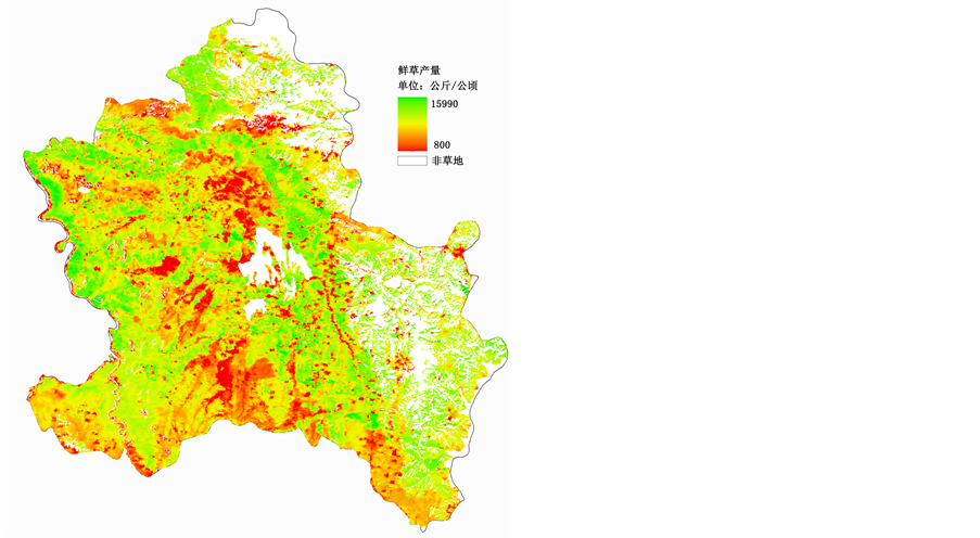
结果显示,2012年若尔盖县全境草原植被平均盖度为82%,平均鲜草产量7759 kg/hm2,草原植被平均盖度、平均鲜草产量空间分布图见图4。
4.2.2. 植被演替度与生物多样性
(1) 2003至2007年工程区植被的演替度分别为0.141、0.139、0.177、0.144、0.152,与2009年相比,植被演替度变化率分别为2.62%、0.91%、4.67%、6.29%、2.90%。
(2) 2003年至2007年工程区生物多样性分别为0.71、0.66、0.62、0.60、0.66,与2009年相比,生物多样性变化率分别为8.46%、5.69%、0.6%、0.61%、0.80%。
4.3. 土壤变化状况
4.3.1. 土壤养分
(1) 2003年至2007年工程区PH值7.3、7.0、6.3、6.8、5.9,与2009年相比,分别减少了3.7%、−14.1%、
Table 2. Task completion table of ceasing herding engineering in Ruoergai from 2003 to 2010
表2. 若尔盖县2003~2010年度退牧还草工程任务完成表(单位:万亩)
 平均盖度 平均产量
Figure 4. The spatial distribution of average coverage and yield about grassland vegetation in Ruoergai at 2012
图4. 2012年若尔盖县草原植被平均盖度、平均产量空间分布图
4.7%、1.7%、5.8%。
(2) 2003年至2007年工程区有机质含量为10.7%、14.8%、19.4%、8.1%、8.6%、6.1%,与2009年相比,分别提高了2.9、−1.5、6.2、0.6、2.5。
(3) 2003年至2007年工程区速效氮含量为335 mg/kg、426 mg/kg、476 mg/kg、405 mg/kg、408 mg/kg,与2009年相比,分别提高了27.2%、13.9%、37%、38.1%、38.5%。
(4) 2003年至2007年工程区速效磷含量为6.0 mg/kg、6.4 mg/kg、7.0 mg/kg、5.9 mg/kg、3.6 mg/kg,与2009年相比,分别减少了14.5%、7.8%、−6.9%、21.3%、7.2%。
(5) 2003年至2007年工程区速效钾含量为152.3 mg/kg、149.7 mg/kg、138.3 mg/kg、137.7 mg/kg、286.3 mg/kg,与2009年相比,分别减少了9.6%、−65.6%、1.7%、11.8%、34.1%。
4.3.2. 土壤水分
(1) 2003年至2007年工程区土壤容重为1.15 g/cm3、0.93 g/cm3、0.83 g/cm3、1.00 g/cm3、1.00 g/cm3,与2009年相比,分别提高了18.2%、−6.7%、15%、−5.8%、−7.7%。
(2) 2003年至2007年工程区土壤含水量为0.54 g/cm3、0.71 g/cm3、0.71 g/cm3、0.65 g/cm3、0.57 g/cm3,与2009年相比,分别提高了−4%、22.8%、30.8%、39.1%、31.8%。
5. 工程效果评价
5.1. 经济效益
5.1.1. 天然草地改良后牧草产值变化
退牧还草工程共实施涉及天然草地任务面积615万亩,各年度工程区经济效益显著。与工程实施前相比,不同年度工程区累计增加鲜草约30.12万吨,以2012年鲜草价格0.2元/kg计算,增加产值约6015.89万元。不同年度工程区经济效益见表3。
5.1.2. 家畜出栏率
若尔盖县2011年家畜出栏率为17.4%,比2006年提高了2.7个百分点。
5.1.3. 家畜胴体重
若尔盖县2011年牛家畜胴体重为100 kg,羊家畜胴体重为25 kg,分别比2006年提高了11.1%和25%。
5.1.4. 人均牧业比例
若尔盖县2011年人均牧业收入占总人均收入的比例为79.8%,与2006年相比提高了5.8个百分点。
5.1.5. 畜牧业产值占农业总产值比例
若尔盖县2011年畜牧业总产值占农业总产值的77.9%,与2006年相比提高了3.9个百分点。
退牧还草工程实施后,牧民增加了相关收入,提高了家禽的产值,降低了家畜死亡损失,人均牧业收入比例和畜牧业产值占农业总产值比例都有所增加,工程经济效益丰厚。
5.2. 社会效益
5.2.1. 就业培训情况
若尔盖县2003年至2010年退牧还草工程共带动了劳动力本地就业11.3万人次,转移就业8800人次,科技培训3100人次数。
5.2.2. 项目拉动内需程度
若尔盖县2003年至2010年度退牧还草工程建设累计投入分别为:钢筋1240吨,价值472.1万元;
Table 3. Economic efficiency table of ceasing herding engineering area in different years
表3. 不同年度工程区经济效益表
运输车次1600次,价值3016.7万元;雇佣人力107,000天/人,价值1182万元。
退牧还草工程的实施,不仅增加了当地人民的就业,培训了农牧民的科技技能,而且带动了钢铁、水泥、运输、人力的需求,极大的拉动了内需,取得了显著的社会效益。
5.3. 生态效益
(1) 2012年若尔盖县各年度工程区内草原植被盖度、高度、鲜草产量和牧场可食比例的均值分别为83%、29.2 cm、7432 kg/hm2、81%,与工程区外相比,分别提高了10.2个百分点、36.9%、6.6%和6.0%。2003~2009年度工程区内外草原植被变化情况见表4。
(2) 工程实施五(七)年后,2003年至2009年度禁牧区比工程实施前盖度和鲜草产量平均分别提高了4.2个百分点和4%,休牧区盖度和鲜草产量分别提高了5.1个百分点和5%。详见表5。
从表5可以看出,禁牧和休牧措施实施后,草原植被的平均盖度和平均产量明显高于工程实施前的
Table 4. Grassland vegetation changes table of ceasing herding engineering area inside and outside in different years
表4. 各年度工程区内外草原植被变化情况表
Table 5. Grassland vegetation changes before and after project implementation
表5. 工程实施前后草原植被变化(单位:% kg/hm2)
水平,措施效果显著。
退牧还草工程的实施,减轻了草原放牧压力,工程区内的草原植被得到了休养生息。工程区内的草原植被的平均盖度、平均高度、平均鲜草产量等均高于非工程区,工程实施五年后,盖度、鲜草产量明显好于工程实施前,工程的生态效益明显。
6. 讨论
经过对2003~2010年度实施的若尔盖国家天然草原退牧还草工程实施效益进行监测,工程的经济、社会、生态效益十分显著。该项工程的实施,在缓解牧区草畜矛盾,保护生物多样性,维护草原生态系统平衡,促进草原资源的可持续发展和牧区经济又好又快发展等方面将起到十分重要的推动作用。
基金项目
农业部草原监测专项资金。