1. 引言
马尾松毛虫(Masion Pine caterpillar, Dendrolimus punctatus Walker)是危害中国南方地区的主要森林虫害之一,每年受灾面积往往近万公顷,造成的经济损失达几十亿RMB/年 [1] ,其特点主要表现为:一是危险性森林病虫害扩散蔓延迅速,对森林资源和自然景观构成巨大威胁;二是常发性森林病虫害面积居高不下,总体呈上升趋势;三是偶发性森林病虫害大面积爆发,损失严重。因而掌握该虫的扩散、蔓延规律对于实施马尾松毛虫治理和防治显得极为重要。马尾松毛虫是马尾松林、湿地松的主要害虫,危害性大,具有繁殖快局部爆发成灾突然的特点。由于林区地形复杂,马尾松毛虫早期危害区多数发生在远离人类活动的偏远区域,马尾松毛虫危害受气象等环境条件影响较大,仅凭传统方法的采用随机抽样法调查越冬代虫口数量,分析和预测当年虫害发生情况,判断是否采取预防措施控制越冬代虫口数量;这些耗时、费力的技术,不能及时发现虫害发生的初期,延误了虫害的最佳防治时机,影响了预报的精确度,造成巨大的经济损失。利用光谱遥感技术大面积及时地监测病虫害,是目前国际上采用的一种技术手段,具有快速、简便、大面积、无破坏、客观以及能够制成各种专题报告等优点,而且是今后林业病虫害监测的最终发展方向。
国内外关于利用TM等多光谱遥感图像监测森林病虫害的报道较多 [1] - [10] ,而利用国产CCD光谱遥感图像监测森林病虫害的报道很少,尤其在多云、小块的松树林混杂在其他树林居多的广西地区,使得遥感监测变得极其困难。本文基于CCD遥感数据和小班数据,以2009广西重大灾害为实例,以广西宾阳和横县交界的这个重要灾害区域为研究区,先利用小班数据提取马尾松和湿地松的空间分布,再利用CCD遥感的红边dVI660和dVI475参数、归一化植被指数(NDVI)、比值植被指数(RVI)等监测马尾松毛虫害,探讨了CCD遥感数据用于监测马尾松毛虫害的可行性。最后还把遥感监测反演结果加载到电子地图上,可以把灾害情况指定到小班位置。
2. 研究区域概况及松毛虫灾害的特点
该区域位于东经:108˚48'8.6738''~109˚10'29.0533'',北纬:22˚45'52.5171''~23˚9'51.9193''。北部属于宾阳县,南部属于横县;正北是宾阳县的农田平地,南面偏西属于地势相对低区域。该研究区域的西部大部区域属于昆仑山的东南余脉,而东部适用于镇龙山西麓的余脉;西南部还是高速公路的三叉口;地势方面处于两山之间谷地而温度高的这种特点加上高速公路的三叉口夜晚容易聚光构成了松毛虫容易发生的环境。
松毛虫为食叶害虫,自幼虫孵化后即可啃食针叶,使松针形成许多缺刻而枯黄,但不能咬断或食尽一根松针,2龄幼虫末期开始嚼食整个针叶,不过食量很少。5~6龄时食叶骤增,末龄幼虫取食量最大,达70%以上。换句话说,危害最为严重的时期为5龄后的一段时间,这就成为遥感的“生物窗口”。
松毛虫虫口密度较高、发生数量多时,一片青山在数日之内,即可被蚕食精光,远望枯黄、焦黑,如同火烧过一样,常被喻为“不冒烟的火灾”。被害的松林,轻的影响生长,重的造成枯死,给生态环境造成巨大破坏。因此,危害后景观变化明显,很容易识别。为遥感的准实时监测提供了可能。
由于受气候因素如光照、湿度、松树种类及生长情况、受害程度等因素的影响,松毛虫具有不同世代的特点。一般来说,松毛虫都要经过卵、幼虫、蛹、成虫四个时期。每一世代所需天数因种类和地区而异,而且同种不同世代,由于每年季节的气候变化差异,各代所需的天数显著不同。就马尾松毛虫而言,完成1世代最短50余天,最长310余天。东北落叶松毛虫2年完成一代,实际要跨3个年度,完成1世代所需的时期就更长了。在特定的气候条件下,病虫有多世代连续暴发的现象。换句话说,森林经常会遭到连续两次以上的破坏,构成了累积的灾害损失。这就给分世代灾害的遥感监测带来了巨大困难。
3. 材料与方法
3.1. 数据收集
3.1.1. 多时相CCD遥感数据
我们选择出2009年5月3日到2010年5月23日的4张可用的我国HJ环境减灾卫星CCD遥感影像的原始图,来分析这次马尾松毛灾害的发生规律。数据的空间分辨率为30 × 30米;有四个光谱波段Band_1 (430~520 nm)、Band_2 (520~600 nm)、Band_3 (630~690 nm)、Band_4 (760~900 nm)。
3.1.2. 其他数据
宾阳县和横县的小班原始数据;“广西森林害虫灾害发生气象条件监测预警预报系统”软件(桂科攻1355010-5项目的成果之一,以下简称“我们的软件系统”)的电子地图,该电子地图可以放大查到县、乡、村、小班的具体位置和空间关系。最重要的还有我们实地调查的灾情记录。
3.1.3. 主要的分析工具
ArcGIS9.3 [11] 、ENVI4.5;“广西森林害虫灾害发生气象条件监测预警预报系统”软件。
3.2. 数据处理
运用ENVI4.5把HJ环境减灾卫星CCD遥感影像的原始图做几何校正,再转到GIS栅格数据格式 [11] ,然后投影到我们的软件系统可以接纳的坐标系统(Spatial Reference: GCS_WGS_1984, Datum: D_WGS_1984)。
通过属性选择宾阳县和横县的马尾松和湿地松的小班数据保存备用。用选择出来的小班矢量数据截取CCD遥感影像在小班位置的栅格值图,供下一步的分析研究用。
3.3. 构建监测指标的理论基础
3.3.1. 植被指数
植被指数是利用卫星不同波段探测数据组合而成的,能反映植物生长状况的指数。植物叶面在可见光红光波段有很强的吸收特性,叶绿素在470 nm和680 nm处各有一吸收蜂,在550 nm附近形成反射峰,在近红外波段(NIR)有很强的反射特性,这是植被遥感监测的物理基础,通过2个波段测值的不同组合可得到不同的植被指数。当森林植物叶内含水量和叶绿素含量减少时(病虫害侵袭),反射率则明显下降,这种近红外反射率的降低是病虫害发生的前兆,是利用卫星遥感技术监测早期森林病虫害的根本依据。
关于构造的植被指数,目前已有40余种,如归一化植被指数(NDVI)、比值植被指数(RVI)、垂直植被指数(PVI)、绿色植被指数(GVI)、差值植被指数(DVI)、增强植被指数(EVI)等 。由于每种植被指数在应用时都有它的适应性和局限性,所以,根据研究区域、植被种类及其长势不同,所选用的植被指数应不同。NDVI是植物生长状况及植被空间分布密度的最佳指示因子,也是应用最广泛的一种植被指数,其与植物分布密度呈线性关系,当植被覆盖度 < 80%时,NDVI随植被生物量呈线性增加,而当植被覆盖度 > 80%时,NDVI对植被检测的灵敏度下降 [12] 。比值植被指数(RVI)是绿色植物的灵敏指示参数,与LAI、叶干生物量(DM)、叶绿素含量相关性高,根据研究区植被及虫害特点,本文选择红边dVI660和dVI475参数、归一化植被指数(NDVI)和比值植被指数(RVI)来尝试。
3.3.2. 红边参数的敏感性分析
500~680 nm范围可见光区反射峰对应波长(记作λrw),与树叶的可见颜色相对应,其值受叶绿素和类胡萝卜素含量比例影响较大。受害初期,叶绿素含量高,针叶成绿色,λrw位于550 nm左右;随受害程度加重,叶绿素减少,类胡萝卜素比例相应上升,针叶变黄,λrw增大,向红光方向移动。
红界区位于叶绿素吸收峰(680 nm附近)与近红外反射区(750~800 nm)之间, 因此红界区的反射特性受叶绿素含量和叶内细胞结构两方面的影响。随松毛虫危害程度的加重,叶绿素含量下降,叶内细胞受损,使红光区最低反射率轻微上升,红外区最大反射率大幅度下降,必然导致红界陡升段斜率(包括最大斜率)的降低。
从红外波段叶绿素吸收区的反射率低点到近红外波段叶片散射的反射率高点这个过渡区称为“红边”区。时间因素及植物病虫害都将影响植物的生长发育,从而使植物光谱强度和光谱特征发生改变,引起红边、蓝边斜率的变化和位置的偏移。当植物叶绿素含量高、生长旺盛时,红边位置向长波方向移动(红移);当植物遭受病虫害或者因污染、物候变化等因素影响导致叶绿素含量减小时,红边位置向短波方向移动(蓝移),这为红边区域的定量遥感分析提供了理论基础 。研究表明,植被光谱“红边”对植被生长状况反应敏感,也证实了红边拐点的波长位置和叶绿素浓度具有正相关 [13] [14] 。因此,通过对红边特性的研究可以监测植被的健康状况。Rock [15] [16] 、Boyer [17] 等都对林木伤害做过研究,得出受害(包括受森林病虫害,森林覆盖下重金属矿藏,大气污染及灾害性天气等灾害)林木树叶叶绿素含量降低,红界光谱蓝移的结论。Qin [18] [19] [20] 还给出了无损伤精确测定色素含量的方法,这些算法还可以排除色素等要素的相互干扰。
3.4. 计算公式
归一化植被指数:
比值植被指数:
这里NIR近红外波段为Band_4(760~900 nm),R红光波段为Band_3(630~690 nm)。
采用倒置高斯模型曲线法提取红界特征参量 ,公式如下:

式中:Bi 是波长λi的光谱值;λi是波段i的波长值。
取平均数值NIR = 830 nm,R = 660 nm (这时用Band_3)或者R = 475 nm (这时用Band_1)。获得dVI660和dVI475两个指数红边参数。
根据上述公式,分别获得各个不同时期的dVI660 和dVI475图、NDVI图、RVI图,根据这次灾害实际调查情况,提取监测指标值,见表1。
3.5. 监测影像图分析
调查发现,2009年5月昆仑山东部余脉山上的松树未受危害,把他作为各个时段该区域的健康树林指标作的对照。
分析各个指标值表明,dVI660比较敏感,各个阶段的指标分布于调查的实际情况比较符合。灾害的发生发展及其演变过程见图1~图4及其说明。
4. 结果与讨论
4.1. 受灾前后各监测指标值比较及遥感监测结果
通过对比不同时期dVI660与dVI475反演图发现受灾前后dVI660与dVI475值明显不同,但是变化趋势一致,未受马尾松毛虫危害的林分dVI660与dVI475值增加,而受危害的林分,dVI660与dVI475数值则一直呈下降趋势,同时受灾程度不同,下降的幅度也不同,受灾程度越大,下降幅度也越大。对于爆发后的重灾区,2009年10月7日至2009年11月5日的dVI475值变化幅度较缓慢,但dVI660值变化较大,比较完整、明显地体现了爆发过程。综合分析不同时期dVI660与dVI475值分布图可以看出,dVI660值的变化幅度 > dVI475值。
实地调查发现这次灾害爆发时间在2009年10月到11月之间,11月是危害最严重的时期,松毛虫进入暴食期,可以将叶食尽,状如火烧,爆发成灾。所以从11月5日的dVI660与dVI475反演图可以清晰

Table 1. The list of damage classifications of different indexes
表1. 灾害级别分类表
 (a)
(a) (b)
(b)
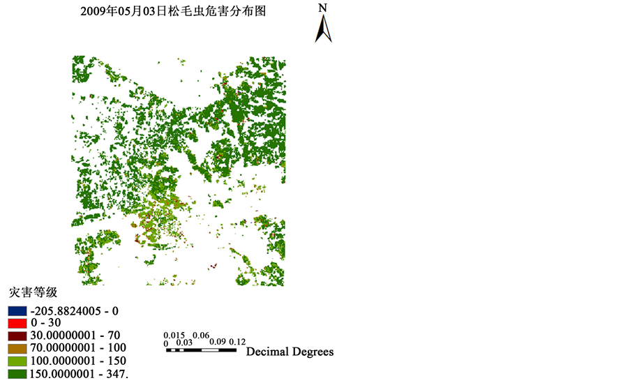
Figure 1. (a) The damage class distribution of Masion Pine caterpillar, Dendrolimus punctatus, in the center of the study area on May 3, 2009. Distribution for the values of dVI660 index; (b) The damage class distribution of Masion Pine caterpillar, Dendrolimus punctatus, in the center of the study area on May 3, 2009. Distribution for the values of dVI660 index
图1. (a)研究的核心区域内2009年05月03日呈现的松毛虫危害的斑点。在研究的核心区域内,2009年05月03日的遥感图已经发现了小部分松毛虫轻度危害的斑块。dVI660指数分布图;(b)这次松毛虫危害最早发生地在宾阳县甘霖镇那宁村委昌山小村一带及其以南的区域,处在高速公路的三叉口地区,南面达到675号公路两旁。灾害级别大部为轻度。dVI660指数分布图。该图是2009年05月03日呈现的松毛虫危害反演图叠加在我们的系统的电子地图上的局部放大

Figure 2. The damage class distribution of Masion Pine caterpillar, Dendrolimus punctatus, in the center of the study area on October 7, 2009, and the values of dVI660 index. During 2009-2010, the damage area extended to the northeast and east of the foot of Zhenlongshang Mountain, including towns of Gantang, Luyu, Shuangqiao, and Gula of Binyan county; towns of Liuqing, Luancheng, Liangqin, Shitang, Taoyu and Lingzhu of Heng county. In areas of heavy defoliation damage, the spectral characteristics were similar to bare ground. The damage degree was Light for most of the area with Moderate damage in some spots. Distribution for the values of dVI660 index
图2. 研究的核心区域内2009年10月07日松毛虫危害分布图,dVI660指数分布图。解说:2009~2010年危害的核心区域扩散到东北部、东部的镇龙山西麓余脉脚下,主要扩散到宾阳县境内甘棠镇、露圩镇、双桥乡、古辣;横县的六景镇、峦城镇、良芹镇、石塘镇、陶圩镇、灵竹镇等乡镇;小部分危害重的区域由于叶子被吃光而露出土壤,因而其光谱特征表现为与裸地相似。灾害级别大部为轻度,局部中度危害
的辨别出dVI660与dVI475值下降的区域。结合地面数据,确定dVI660 ≥ 150为健康林分,dVI660下降到<150为轻度受灾区,dVI660下降到<100为中度受灾区,dVI660下降到<70为重度受灾区,dVI660下降到<30为成灾区,dVI660下降到<0为水体或者其他区域。据表2获得2009年11月5日健康林分面积268.6975 hm,轻度受灾面积为6891.2328 hm,中度受灾面积为13148.9155 hm,重度受灾面积为6539.1710 hm,成灾区面积为347.4999 hm,水体或者其他面积为96.1550 hm。从2009年10月7日到11月5日的灾害爆发过程看:健康林分面积减少到1.22%;轻度受灾区面积增加了51.19%;中度受灾区增加了33.119倍,重度受灾区面积增加了34.916倍,成灾区面积增加了3.709倍,水体或者其他区域区面积增加了2.957倍。
NDVI和RVI在轻度有些反应,中度和重度没有反应,不可用;dVI475指标在轻度有些反应,中度敏感,重度没有反应,不可用。
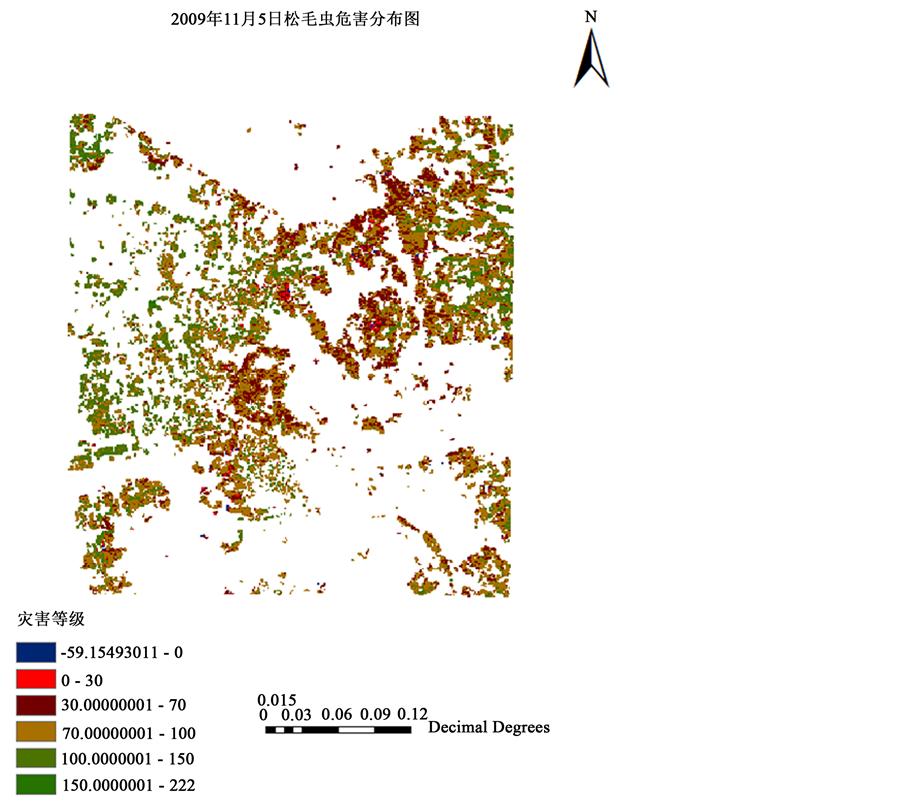
Figure 3. The damage class distribution of Masion Pine caterpillar, Dendrolimus punctatus, in the center of the study area on November 5, 2009, and the values of dVI660 index. During October 7 to November 5 of 2009, the damage became more intense with total defoliation in some areas exposing the soil surface. The spectral characteristics were similar to bare ground. The damage degrees were Moderate to Severe in most areas with Total loss in some spots indicting the pest outbreak occurred between October 7 to November 5 of 2009. Distribution for the values of dVI660 index
图3. 研究的核心区域内2009年11月05日松毛虫危害分布图,dVI660指数分布图。解说:2009~2010年危害扩散到的核心区域危害加重;危害重的区域由于叶子被吃光而露出土壤,因而其光谱特征表现为与裸地相似。灾害级别大部为中度和重度,局部成灾;说明灾害爆发发生在2009年10月07日到11月05日之间
Table 2. The estimated damage areas on different dates based on the dVl660 index (hectare)
表2. dVI660指标的不同灾害级别面积估算表(公顷)

Figure 4. The damage class distribution of Masion Pine caterpillar, Dendrolimus punctatus, in the center of the study area on May 25, 2010, and the values of dVI660 index. The damaged areas were mostly recovered with higher degrees of damage in the areas of the three-way intersection of the highways up to both sides of the public road 675 in the south. Distribution for the values of dVI660 index
图4. 研究的核心区域内2010年05月25日松毛虫危害分布图,dVI660指数分布图。解说:2010年5月25日,大部份危害区域已经恢复,但是在高速公路的三叉口地区,南面达到675公路两旁危害还比较重
4.2. 对遥感监测结果的评价与分析
我们当时对这次松毛虫灾害做了比较详细的调查,多次走访,对这次灾害的源头也做了调查,《中国气象报》 [21] 、《南国早报》 [22] 、《广西科技信息网》当时都对灾害的发生过程做了详细报道。地面调查表明这次马尾松灾害的实际发生和爆发情况与dVI660的实际推演基本相符。。
4.3. 讨论
本文只是利用遥感红边参数dVI660确定马尾松受害程度及面积,进行相关分析建立一合适的处理程序来提取虫害信息,准确度的影响如何,有待于进一步探讨,红边参数dVI660的变化受多种要素的影响,如何剔除其他方面的影响,研究 [23] [24] [25] [26] [27] 给出了优秀算法,可以参照应用,同时不同的卫星,可能会有差异,进行松毛虫灾害的定量监测有待于进一步研究。
HJ系列卫星CCD传感器的设计是3~5天重访一次,但是目前在运行的卫星由于数目不足,实际重返时间是一个月。好在还有许多卫星可以应用,例如GF系列卫星、ZY系列卫星、美国的Land8卫星(免费使用),尽管MODIS数据空间分辨率不高,但是具有高时间分辨率。所以同时使用不同传感器和不同时相的遥感数据,进行多源信息的融合,加强遥感数据的信息挖掘 [23] [24] [25] [26] [27] ,尤其注意融入微波遥感数据,可更好地发挥不同遥感源的优势互补,有利于综合、准确地分析虫害危害情况。同时,高光谱、高空间分辨率也是今后卫星遥感监测病虫害的重要发展方向。
5. 结论
本文基于CCD数据,分别利用遥感红边参数、归一化植被指数、比值植被指数等监测马尾松毛虫害,其研究结果证明了利用CCD数据进行马尾松毛虫害监测的可行性,并在监测速度、监测范围及成本上都优越于过去传统的调查方法,从而为大尺度监测马尾松毛虫害的发生动态提供了广阔的应用前景。研究结果表明,CCD数据对受灾区域各个灾害级别都较为敏感,4个监测指标相比,dVI660的敏感性和准确度较好。应用遥感可以尽可能早地发现松毛虫灾害初始发生区域、程度等情况,可以为预警预报提供技术支持,有重要意义。我们对传统做法做了比较好的改进 [28] [29] [30] [31] ,效率提高15倍,但是遥感方法的优势仍是显著的。
而且反演结果可以通过“广西森林害虫灾害发生气象条件监测预警预报系统”与气象、传统监测 [28] [29] [30] [31] 的虫情数据等信息对接,通过系统的电子地图可以放大把灾情指定到县、乡、村、小班的具体位置,并且支持相关的空间关系,直接应用于业务服务,有很好的实际意义。
致 谢
广西宾阳、横县、武鸣等县林业病虫害防治站及其相关同事的协助,还有《林业世界》期刊编辑们的帮助。
基金项目
广西自治区科技厅“科技攻关计划”项目(桂科攻1355010-5);广西重大科研开发项目(桂科鉴字[2014]323)。
NOTES
*通讯作者。