摘要:
本研究基于Landsat 8 OLI卫星影像,采用云南省中部地区的5个湖泊,即滇池、抚仙湖、阳宗海、星云湖和杞麓湖作为研究对象,其中滇池、星云湖、杞麓湖是富营养化湖泊,比较了两种水体指数,NDWI和MNDWI提取湖泊水体边界的精确度。结果表明:由于近红外波段能够较好的区分植被和水体,但也带来了藻类覆盖的水域容易被误识别为植被的情况。因此,采用NDWI提取的富营养化湖泊水体面积比实际值偏小,中红外波段对水分含量较为敏感,在富营养化湖泊中采用该指数可以有效的区分陆地和水体,排除藻类的干扰。因此,MNDWI更适合用于富营养化湖泊的水体边界提取。
Abstract:
This study is based on the Landsat 8 OLI satellite images, and uses 5 lakes as sample, which are Dianchi Lake, Fuxian Lake, Yangzonghai Lake, Xingyun Lake and Qilu Lake, there are all located in the central region of Yunnan province, and Dianchi Lake, Xingyun Lake, Qilu Lake are eutrophic lakes. The accuracy of NDWI and MNDWI index for lake water boundary extraction was compared. The results show that the near infrared band can distinguish vegetation and water body better. But it has also brought the algae covered waters that can be mistakenly identified as vegetation. Therefore, the water area of eutrophic lake extracted by NDWI is smaller than the actual value. The infrared band is more sensitive to moisture content. Using this index in eutrophic lakes can effectively distinguish between land and water, eliminate algal interference. Therefore, the MNDWI index is more suitable for water boundary extraction in eutrophic lakes.
1. 引言
湖泊是世界上淡水资源存储的主要场所之一,也是重要的可利用淡水来源。准确监测湖泊面积的变化对人类掌握湖泊变化和演变趋势具有重要意义。目前监测湖泊面积变化的主要手段是利用卫星遥感技术。用于提取湖泊水体信息的遥感数据和方法有很多。在遥感数据方面,自从美国USGS开放Landsat卫星数据以来,Landsat系列卫星的数据在世界范围内获得了广泛的应用 [1] - [6] ,利用该系列数据,可以研究从1972年至今的地表湖泊的变化情况。在湖泊水体信息提取技术方面,1996年,McFEETERS [7] 提出了利用绿光和近红外波段进行计算的NDWI指数来提取水体信息,该指数能较好的区分陆地植被和水体,同年Gao [8] 也提出了一个NDWI指数,其计算所采用的波段是近红外和中波红外波段,与McFEETERS的方法不同,但指数的命名相同。2005年,徐涵秋使用改进的NDWI指数(MNDWI)提取水体信息 [9] ,该指数能够较好的识别城镇区域,比较适合用于城市水网的水体提取。2011年ZHANG Fang-fang等 [4] 的研究成果和2016年Haibo等 [10] 的研究结论均支持上述观点。2012年,Campos等比较了上述经典的三种水体指数的效果,认为MNDWI和Gao的NDWINIR/MIR均取得了较好的效果,而McFEETERS的NDWI效果较差。2015年,Gautam等采用多个水体指数(NDWI、MNDWI、WRI)和监督分类以及K-T变换的方法提取印度Bangalore地区的水系 [6] ,采用的是MNDWI指数反演的结果来验证其它指数的精确度。2017年,宋英强等 [11] 基于AdaBoost算法,提高了Landsat 8 OLI提取水体的精确度。同年,Sarp, G,等 [12] 的研究认为提取水体边界的方法中精确度从高到低的方法是支持向量机、NDWI、MNDWI和AWEI。
随着人类生产、生活带来的污染物排入湖泊中,导致湖泊富营养化,这成为湖泊环境恶化的重要后果之一。由于富营养化的湖泊在藻类爆发的时候,湖泊表面漂浮着厚薄不一的藻类物质,与陆地上的植被容易混淆,根据前人的研究结论,McFEETERS的NDWI和徐涵秋的MNDWI是最经典的也是最简单快捷的水体提取方法,但是这两种水体指数用于提取富营养化湖泊水体边界的效果并没有相关的研究报道。本研究选取位于云南省中部地区的5个湖泊作为研究对象,这5个湖泊分别是滇池、阳宗海、抚仙湖、杞麓湖和星云湖,其中滇池、杞麓湖和星云湖是常年藻华爆发的湖泊。采用“91卫图助手企业版”软件中的无偏移的谷歌历史影像,人工勾画湖泊边界作为准确的参考,然后基于Landsat 8 OLI影像,比较NDWI (下文所提到的NDWI均为McFEETERS的NDWI)、MNDWI两种水体指数提取湖泊边界,优选出即简单快捷,又适合于富营养化湖泊水体边界提取的方法。
2. 数据与方法
2.1. 研究区概况
位于滇中地区的5个湖泊相距并不遥远,其中滇池是云南省面积最大的湖泊,分为草海和外海,由于紧临省会昆明市主城区,北部的草海的水质主要受到生活污染源的影响,南部的外海主要受到农业面源污染,从2001年开始,周年性的爆发水华 [13] 。阳宗海位于滇池的东北部,2013年总氮、总磷稳定在Ⅲ类水质附近 [14] 。抚仙湖位于滇池以南,是全国面积最大且水质优秀的深水湖泊,水质常年稳定保持在Ⅰ类水附近 [15] [16] 。星云湖位于抚仙湖南边,历史上,星云湖的水通过隔河流向抚仙湖,1995年星云湖开始出现藻类水华,此后,周年性的爆发藻类水华,2008年开展了出流改道工程,抚仙湖的水流向星云湖,避免了星云湖的劣质水污染抚仙湖 [17] 。杞麓湖位于星云湖以南,是通海县的母亲湖,由于通海县是重要的蔬菜基地,杞麓湖周边有大量的菜地,受到农业面源污染,目前杞麓湖属于中度-重度富营养化湖泊,藻类多在六月爆发 [18] 。
2.2. 数据源及预处理
本研究采用30米分辨率的Landsat 8 OLI传感器的影像作为计算水体指数的数据源,来自于地理空间数据云(http://www.gscloud.cn/)。采用0.6米分辨率的谷歌历史影像(通过“91卫图助手企业版”软件获得)作为验证的数据源,选取两个数据源同一天都有观测数据的影像来进行研究,经过查档,选定2016年11月22日的影像作为研究对象。谷歌影像中,滇池外海的拍摄日期是2016年11月22日,草海的影像拍摄日期距离该日期最近的有2016年12月26日的,相差一个月。因此,本研究对于滇池仅选用外海作为研究对象。
对于Landsat 8 OLI数据,下载的是L2级数据产品,已经经过系统的几何校正。由于本研究需要计算遥感指数,因此,大气校正必不可少,本研究对Landsat 8 OLI影像采取辐射定标后进行FLAASH大气校正的预处理方法。
2.3. 研究方法
水体指数采用下列两种 [7] [9] :
(1)
(2)
其中,Green为绿光波段,NIR为近红外波段,MIR为中红外波段。
根据最初提出上述两个水体指数的文献所阐述的计算原理,其计算结果大于0的区域为水体,小于0即为陆地。因此,本研究取0为阈值计算水体边界。对于基准参考影像,采用目视解译的方法勾画水体边界,用于验证水体指数反演结果的精确度。
本研究使用的软件有“91卫图助手企业版z”、ENVI5.3、ArcGIS10.3。
3. 结果与分析
根据表1、图1和图2所示,在藻类覆盖面积较大的湖泊(星云湖),NDWI的精确度非常低,MNDWI
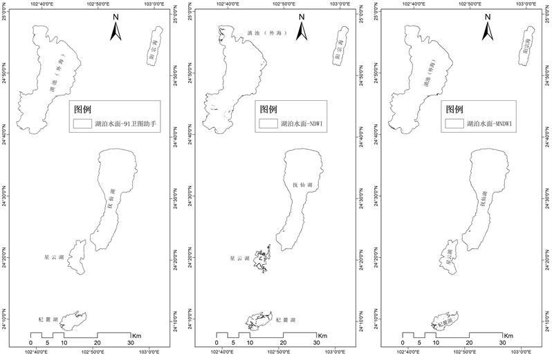
Figure 1. Water boundaries extracted by different methods
图1. 不同方法提取的水体边界

Figure 2. Comparison and analysis of two Water Index and reference images for water boundary location
图2. 两种水体指数和参考影像提取水体边界位置叠图对比分析
可以取得较好的水体边界提取效果,适用于富营养化湖泊的水体边界提取。对于藻类覆盖面积较少的湖泊,两个水体指数的区别不明显,造成NDWI提取误差的区域主要位于藻类覆盖的区域,造成MNDWI误差的主要区域位于岸边附近水域。
杞麓湖东部的谷歌影像拍摄日期是2016年11月21日,与本研究的日期相差一天,由于东部湖区有浮萍覆盖,虽然研究结果显示MNDWI反演的杞麓湖面积与真实面积相差很小,但是东部湖区水域的位置两者相差较大,这是因为两个影像虽然相差仅有一天,但由于风的作用,导致浮萍漂移,而面积基本没有变化。
本研究取了研究区域典型地物,分析其在不同波段的平均反射率,借此分析上述结果的主要原因,如图3所示。NDWI指数采用水体在绿光和近红外光之间的反射率差异,并利用了叶绿素a在近红外光波段的强烈反射的特征,将植被与水体区分开。水体在绿光波段反射率高,到了近红外波段,反射率很低,于是用绿光波段的反射率减去近红外波段的反射率,结果往往是大于0的,而叶绿素a在绿光波段是强烈吸收的,在近红外波段有强烈的反射,在植被区域,用绿光波段的反射率减去近红外波段的反射率得到的结果往往是负值,由此将水体和植被区分开。
由于NDWI指数可以较好的区分植被和水体区域,对于藻类覆盖的水域,往往误识别为植被区域,于是造成了水体区域的漏分。在光谱的中红外(SWIR1)阶段,绿色植物的光谱响应主要被1.4 μm、1.9 μm

Table 1. Lake area and accuracy rate extracted by different methods
表1. 不同方法提取的湖泊面积和正确率
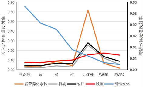
Figure 3. Spectral characteristics of different ground objects
图3. 不同地物的光谱特征
和2.7 μm附近的水的强烈吸收带所支配。随着植物含水量减少,植物在中红外波段的反射率明显增大 [7] [9] 。因此,对于蓝藻覆盖的水体,由于水分含量高,带来中红外波段的强烈吸收,导致绿光波段的反射率减去中红外波段的反射率的值往往为正值,排除了藻类对水体提取的干扰。本研究认为上述原理是在富营养化湖泊水体提取中MNDWI优于NDWI的主要原因。
此外,MNDWI提取水体误差的主要原因也可能是由于岸边水深较浅,藻类、浮萍等含叶绿素a较高的物质较多,导致中红外波段水汽吸收较少,反射率增大,从而导致MNDWI计算结果为负值,与陆地特征混淆所致。
4. 结论
1) MNDWI更适合于提取富营养化湖泊的水体边界。
2) 对于水深较浅的岸边区域,MNDWI也会存在一定的误差。
3) 对于贫营养湖泊,NDWI和MNDWI指数提取湖泊边界的效果差异并不明显。
资助信息
云南省高校测绘与地理空间信息技术重点实验室(2014061)、玉溪市社会科技发展专项:玉溪市实施可持续发展战略研究(201701)、云南省应用基础研究项目(2016FD112,2015FD090、2013FD051)和云南省教育厅科学研究基金项目(2015C083Y)联合资助。