Abstract:
During 18-20, June and 17-18, September in 2014, there occurred two infrequent heavy rain in western Guizhou caused by Inverted Trough of Typhoon, which results in serious disaster. Based on observations and NCEP reanalysis data, the two heavy rain cases caused by inverted trough of typhoon in western Guizhou was analyzed. Analysis found that: The two typhoon trough heavy rains are produced under the condition that the stability of the subtropical high pressure of 588 line is in the western edge of Hunan. The typhoons weaken into the tropical depressions after landing. After the tropical depressions under the influence of easterly airflow on the south side of the subtropical high westbound to western Guangxi, rainstorms happen which the northeast of typhoon trough affects in Guizhou. The southeast jet from the periphery of typhoon depression brings abundant water vapor and unstable energy from the South China Sea to the rainstorm area. The typhoon trough rainstorm of Wimason (on July 19-20, 2014) is effect on the single typhoon trough. Although the thermal instability stratification lasted longer, both the ascending movement and convergence or divergence are not strong, corresponding to weak rainstorm intensity and the less and scattered sites. Both the low-level shear and the typhoon trough impact on the typhoon trough rainstorm of Seagull (on September 17-18, 2014). And the strong water vapor convergence is formed in the southerly airflow between the two systems. The ascending movement and convergence or divergence last longly, corresponding to the long time of rainstorm rainfall and the more and concentrated sites. The analysis of weather system configuration on forecast point over the western Guizhou and the distribution variation characteristics of water vapor flux and water vapor flux divergence have good indication function for the prediction and warning of typhoon trough in western Guizhou.
1. 引言
贵州西部暴雨的发生频率虽没有中东部高,量级也没有中东部大,但贵州西部山高谷深,地形切割分明,暴雨,特别是大暴雨由于降雨突发性强、强度大,常常导致贵州西部山洪爆发、河水猛涨,滑坡、泥石流,城镇内涝等自然灾害时常发生,给贵州西部国民经济和人民生命财产造成严重损失。造成贵州西部暴雨发生的主要天气系统有地面冷锋、高原槽、印缅槽、西南涡、切变线、低空急流等,对这类天气系统造成的暴雨研究颇多 [1] [2] [3] [4] ,得出的结论对贵州暴雨的预报预警有很好的指示意义。然而对台风倒槽影响贵州西部并造成暴雨的过程分析则是少之又少。台风在广东、广西登陆后其强度快速减弱为热带低压,热带低压常常沿副热带高压南侧偏东气流西移北抬,其形成的台风倒槽外围云系常常影响贵州形成降雨天气,局地降雨量有时还会达到暴雨及以上量级,但造成全省大范围暴雨天气(指贵州境内有5县市以上出现暴雨)的个例并不多见。统计表明:1999~2010年的12年间贵州境内共出现了108次暴雨天气过程,只有3次暴雨天气过程是由台风倒槽引起。周明飞 [5] 等对这3次由台风倒槽引起的贵州暴雨天气过程进行了诊断分析,分析表明:这三次台风倒槽引起的暴雨天气过程分别是由单一台风倒槽影响造成、台风倒槽与低涡切变共同影响造成和台风倒槽与地面弱冷空气结合影响造成。由单一台风倒槽影响造成的暴雨天气过程热力不稳定层结维持时间较长,上升运动、低层辐合与高层辐散均不强,对应产生的降水虽持续时间长,但小时雨量不大,暴雨站点少而分散;而由低涡切变和台风倒槽共同影响产生暴雨天气过程,两系统之间偏南气流形成强的水汽辐合、上升运动与辐合辐散均较强,上升运动与辐合区发展层次也较高,对应产生的暴雨集中且站点多,降雨时间长;由地面弱冷空气与台风倒槽结合产生的暴雨天气过程,冷暖气流交汇形成的水汽辐合区范围不大,但具有强烈上升运动和动力场发展,致使产生的暴雨虽范围小、但强度大。
2014年7月19~20日和9月17~18日贵州西部发生了两场由台风倒槽引起的暴雨天气过程,其中9月17~18日的台风倒槽暴雨天气过程引发严重的洪涝灾害,本文利用MICAPS资料、地面加密自动站观测资料和NCEP再分析资料等对2014年7月19~20日和9月17~18日发生在贵州西部的两次台风倒槽暴雨天气过程进行对比分析,以揭示贵州西部台风倒槽暴雨过程形成的背景与机理,为今后贵州西部台风倒槽暴雨过程防洪抗灾预测预报服务提供参考依据。
2. 两次强暴雨过程概况
2014年7月19日早晨7时左右,2014年第9号台风“威马逊”在广西西北部防城港附近登陆,受其减弱西移北抬台风倒槽影响,2014年7月19日夜间~21日白天贵州西南部的黔西南、六盘水南部等地普中到大雨,个别乡镇出现暴雨(以下简称“威马逊”台风倒槽暴雨)。从20时贵州区域自动气象站24 h降雨量分布图看(图1(a),图1(b)):20日降雨量超过25 mm的县市有11个,强降雨落区主要出现在贵州的黔西南、六盘水南部,最大值为黔西南普安站的49 mm,该站1 h最大降雨量为7.8 mm,出现在19日22时(北京时,下同)。21日降雨量超过50 mm的县市有4个,超过25 mm的县市有3个,强降雨落区出现在贵州在黔西南、六盘水南部,最大值出现在六盘水的盘县站,降雨量为89.3 mm,该站1 h最大降雨量为22.6 mm,出现在21日13时。19日20时至21日20时48 h降雨量超过100 mm的县市有2个,超过50 mm的县市有5个,超过25 mm的县市有8个,最大值出现在六盘水的盘县站,降雨量为133.1 mm。
2014年9月16日夜间23时左右,2014年第15号台风“海鸥”在越南的北部登陆,受其减弱西移热带低压东北侧台风倒槽和高原东移低涡切变影响,2014年9月16日夜间~18日白天贵州省西部出现了
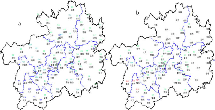

Figure 1. Precipitation of Guizhou (unit: mm; (a) from 20:00 BT 19 to 20:00 BT 20 July 2014, (b) from 20:00 BT 20 to 20:00 BT 21 July 2014, (c) from 20:00 BT 16 to 20:00 BT 17 September 2014, (d) from 20:00BT 17 to 20:00BT 18 September 2014)
图1. 贵州省降雨量分布图(单位:mm,(a) 2014年7月19日20时至20日20时;(b) 2014年7月20日20时至21日20时;(c) 2014年9月16日20时至17日20时;(d) 2014年9月17日20时至18日20时)
一次大范围的暴雨到大暴雨天气过程,从20时区域自动气象站24 h降雨量分布图可见(图1(c),图1(d)):17日降雨量超过100 mm的县市有3个,超过50 mm的县市有23个,强降雨中心出现在黔西南、六盘水、安顺,最大值出现在黔西南的普安站,降雨量为130.1 mm。该站1 h最大降雨量为17.2 mm,出现在17日20时。18日降雨量超过100 mm的有1个县市,超过50 mm的有9个县市,强降雨中心出现在毕节西南部、六盘水,黔西南西北部,最大值出现在六盘水的盘县站,降雨量为112.9 mm,该站1 h最大降雨量为10.9 mm,出现在18日00时。从16日20时到18日20时48 h降雨量看,降雨量超过200 mm的县市有2个,超过100 mm的县市有16个,超过50 mm的县市有36个,最大值出现在六盘水的盘县站,降雨量为228.7 mm。此次暴雨洪涝灾害共造成六盘水53,533人受灾,紧急转移安置2006人,造成直接经济损失1539.91万元。
3. 两次台风倒槽暴雨影响系统分析
3.1. “威马逊”台风倒槽暴雨过程的影响系统分析
2014年7月19日20时500 hPa图上(图略),588线位于湖南西部边缘,584高压位于川西北,脊线位于30˚N~35˚N之间,“威马逊”台风中心位于海南西部洋面上,19日7时左右在广西防城港市光坡镇沿海第三次登陆,登陆时中心附近最大风力达15级,最低气压988 hPa。“威马逊”台风以强台风和台风级别在广西境内维持了9 h (7月19日7~16时),为有气象记录以来的最长持续时间。19日下午减弱为热带低压,台风低压在副热带高压南侧偏东气流引导下西行,19日20时台风低压中心到达广西西部,台风倒槽位于广西西北部和贵州西南边缘;20日08时,台风低压中心北抬至广西西北部边缘,台风倒槽移至云南东部边缘,强降雨区位于倒槽东侧,贵州西南部出现暴雨;20日20时,台风低压中心西移北抬至云南东南部,倒槽西移至云南境内,贵州西南部降雨减弱,21日白天,台风低压中心西移至云南南部,台风倒槽影响贵州西南部,贵州西南部降水再次增强,直至21日午后,台风低压在云南境内减弱消失,贵州降雨天气结束。700 hPa图上,19日20时台风倒槽位于云南东南部边缘到贵州西南部,从东南沿海到、广西、湖南、贵州中东部为一致的偏南气流,最大风速为河池的32 m/s。20日08时台风倒槽稍南退,东南气流有所减弱,最大风速为贵阳站的20 m/s。20日20时台风倒槽位置少变,东南气流减弱为8~14 m/s,最大风速为贵阳站的14 m/s,21日08时东南气流扩散至云南中东部,最大风速为贵州威宁、贵阳的12 m/s,台风倒槽位于云南东北部。850 hPa图上,19日20时台风倒槽位于广西中部,从东南沿海到广西南部为偏南气流,最大风速为南宁站的24 m/s。20日08时台风西移北抬至云南东南部边缘到贵州西南部,广东、广西、湖南、贵州、四川中东部均转为4~12 m/s的东南气流,最大风速为广西境内的12 m/s。东南气流从南海给贵州西南部带来充足的水汽和不稳定能量。
3.2. “海鸥”台风倒槽暴雨过程的影响系统
2014年9月16日20时500 hPa图上(图略),588线位于湖南西部边缘,584高压脊控制贵州中东部,脊线在25˚N附近,甘南至川西北有槽,我省为暖脊控制。“海鸥”台风中心位于海南西部洋面上。16日23时左右在越南的北部登陆,登陆时台风中心最低气压为975 hPa,台风中心附近最大风力达12级。登陆后强度快速减弱,17日下午减弱为热带低压,17日夜间,台风倒槽与低涡切变槽在贵州西部靠近并结合,台风倒槽与切变槽的结合使倒槽东侧偏南风加大,此过程区域性暴雨区出现在两系统之间东南侧的偏南气流中。台风倒槽西移出贵州后,从地面至500 hPa,贵州均转为偏南气流影响,贵州强降雨天气结束。700 hPa图上,16日20时陕南–川东–盆地南部有低涡切变,台风倒槽位于云南东南部边缘到贵州西南部,从东南沿海到广西、湖南、贵州中东部为一致的强劲东偏南气流,最大风速为北海站的42 m/s。17日08时低涡切变东南移南压至川东–盆地南部,台风倒槽北抬东移至贵州西部,东南气流有所减弱,最大风速为南宁站的28 m/s。17日20时低涡切变与台风倒槽结合,东南气流继续减弱,最大风速为白色站的20 m/s,18日08时东南气流继续减弱,最大风速为贵阳站的14 m/s。850 hPa图上,16日20时台风倒槽位于广西南部边缘,从我省中东部到广西、湖南为一致的强劲东偏北气流,最大风速为南宁站的36 m/s。17日08时低涡切变位于川东–盆地南部,台风倒槽北抬贵州南部边缘,东南气流有所减弱,广东、广西、湖南为一致的14~30 m/s东南气流,最大风速为南宁站的30 m/s。17日20时台风倒槽北抬至贵州西北部与低涡切变结合,东南气流继续减弱,最大风速为白色站的18 m/s,18日08时东南气流继续减弱北扩,最大风速为白色站的16 m/s。中低层强劲东偏南气流给我省西南部、西部带来充足的水汽和不稳定能量。
4. 物理量场特征
4.1. 水汽条件对比
从强降雨中心上空的水汽通量分布看,两次暴雨开始前在850 hPa与700 hPa之间均出现水汽通量大值中心(图2(a)、图2(b)),“威马逊”暴雨水汽分布主要在500 hPa以下,水汽通量最大值中心出现在19日20时前后700 hPa左右,为1.7 g/(cm∙hpa∙s),“海鸥”暴雨的水汽分布达到400 hPa,水汽通量最大值为25 g/(cm∙hpa∙s),出现在17日02时前后,说明”海鸥”暴雨比”威马逊”暴雨的水汽条件更好,两次暴雨均出现了2~3个个水汽通量散度强中心区(图略),呈现为增强–减弱–增强的趋势,这与低空西南急流及风速风向辐合强度的变化基本一致。
4.2. 不稳定能量对比
不稳定层结为强对流天气发生发展提供了从位能转化为动能的基本条件 [6] 。从表1的威宁、贵阳、兴仁站点探空的K指数、Si指数等稳定度参数对比分析看,两次暴雨过程贵阳、兴仁两站K指数在38℃~43℃之间,Si指数在−0.13℃~−3.71℃之间,表示暴雨期间大气暖湿,水汽充分;从Δθse(500~700)看,暴雨期间威
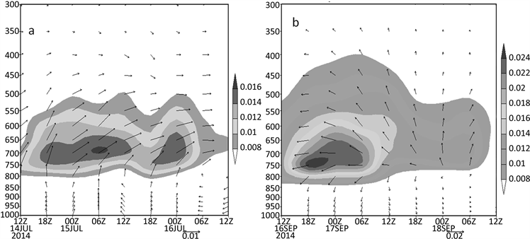
Figure 2. Height-time section of wind vector and water vapor flux (shading, unit: g/(cm∙hpa∙s) along the storm center (25.7˚N, 104.5˚E) ((a) from 20:00 BT 19 to 20:00 BT 21 Jul 2014, (b) 20:00 BT 16 to 20:00 BT 18 Seb 2014)
图2. 沿暴雨中心(25.7˚N, 104.5˚E)风矢量场及水汽通量的高度–时间剖面图(单位:g/(cm∙hpa∙s,(a) 2014年7月19日20:00~21日20:00,(b) 2014年9月16日20:00~18日20:00)

Table 1. Comparison and analysis of stability parameters of Weining, Guiyang and Xingren (Xingren for 14 h)
表1. 威宁、贵阳、兴仁(兴仁为14 h)探空站点稳定度参数对比分析
宁、贵阳、兴仁Δθse (500~700)在−3.06℃~−15.14℃之间,表明暴雨期间大气层结均为不稳定。
从两次暴雨中心θse的高度–时间剖面图(图3(a)、图3(b))分析,近地层900 hPa之下均为大值区,表明强降雨区域在强降雨期间维持高能;在中层(850~500 hPa)附近,均为低值区,分别有2~3个336~348 k的低值中心,暴雨期间从低层到高层呈明显的高–低–高形态;高层、低层分别为θse场的高值区,中间部分向下凹陷,这种分布一直维持到暴雨天气过程结束,表明能量锋一直维持暴雨区。
4.3. 动力条件对比
从强降雨中心垂直速度的高度–时间剖面图(图4(a)、图4(b))上看,两次暴雨期间强降雨区上空都维持长时间的垂直上升运动,“威马逊”暴雨区上升运动最强时上升气流到达200 hpa,但上升运动存在明显增强–减弱–增强–减弱的特征,与“威马逊”暴雨的降雨特征一致。而“海鸥”暴雨上升气流最强时只到达350 hpa,但暴雨区一直维持较强的上升运动,稳定的上升气流使水汽不断凝结产生长时间的强降雨。
从强降雨中心散度的高度–时间剖面图(图5(a)、图5(b))上看,两次暴雨期间700 hpa以下一直为辐合区(负散度区),而700 hpa以上一直为辐散区(正散度区),但两者的差别在于低空辐合区的强度,“海鸥”暴雨的辐合区强度比“威马逊”暴雨强,同时“海鸥”暴雨在9月17日高空的辐散中心值比“威马逊”暴雨在7月20日高空的辐散中心值大,说明“海鸥”暴雨高空的抽吸作用比“威马逊”强烈。
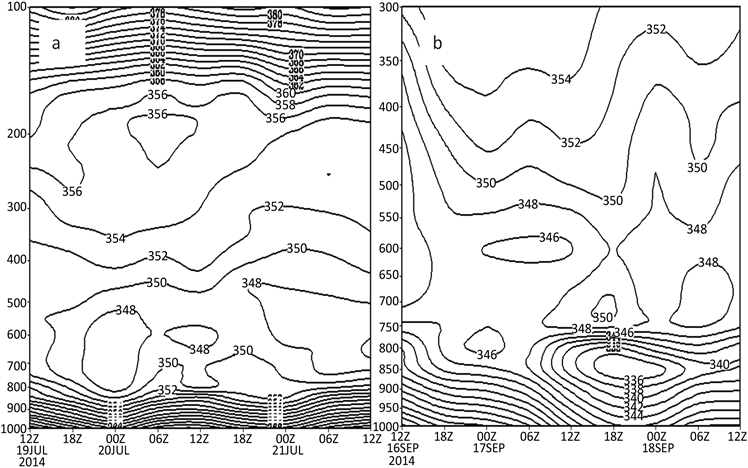
Figure 3. Height-time section of θse along the storm center (25.7˚N, 104.5˚E) (unit: k, (a) from 20:00 BT 19 to 20:00 BT 21 Jul 2014, (b) 20:00 BT 16 to 20:00BT 18 Seb 2014)
图3. 沿暴雨中心(25.7˚N, 104.5˚E) θse的高度–时间剖面图(单位:k,(a) 2014年7月19日20:00~21日20:00,(b) 2014年9月16日20:00~18日20:00)
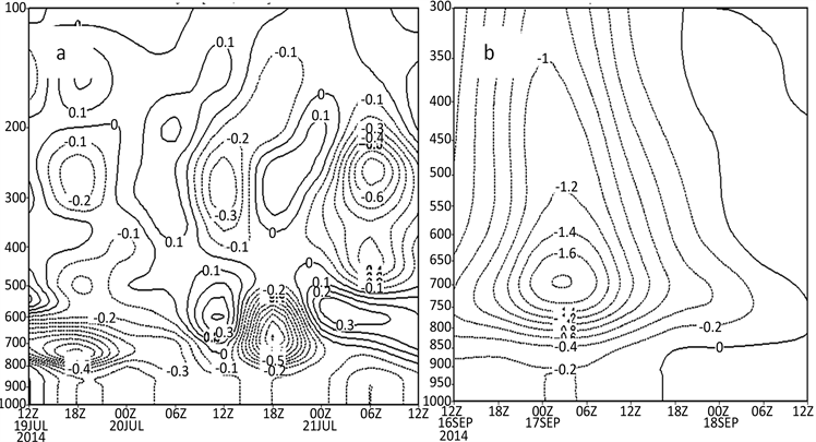
Figure 4. Height-time section of vertical speed along the storm center (25.7˚N, 104.5˚E) (unit: m/s, (a) from 20:00 BT 19 to 20:00 BT 21 Jul. 2014, (b) 20:00 BT 16 to 20:00 BT 18 Sep. 2014)
图4. 沿暴雨中心(25.7˚N, 104.5˚E)垂直速度的高度–时间剖面图(单位:m/s,(a) 2014年7月19日20:00~21日20:00,(b) 2014年9月16日20:00~18日20:00)
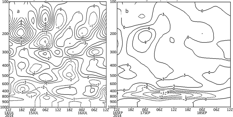
Figure 5. Height-time section of divergence field (unit: 10−5s−1) along the storm center (25.7˚N, 104.5˚E) ((a) from 20:00 BT 19 to 20:00 BT 21 Jul 2014, (b) 20:00 BT 16 to 20:00BT 18 Sep. 2014)
图5. 沿暴雨中心(25.7˚N, 104.5˚E)散度的高度–时间剖面图(单位:10−5s−1,(a) 2014年7月19日20:00~21日20:00,(b) 2014年9月16日20:00~18日20:00)
5. 结论与讨论
两次台风倒槽暴雨天气过程均是在副热带高压588线稳定维持在湖南西部边缘的条件下产生的,台风登陆后减弱为热带低压,热带低压在副热带高压南侧偏东气流影响下西行到达广西西部后,其东北部台风倒槽影响贵州时产生暴雨;台风低压外围的东南急流从南海给贵州西部暴雨区带来充足的水汽和不稳定能量。
“威马逊”台风倒槽暴雨过程副热带高压位置偏北,没有明显的西风带系统与台风倒槽结合,暴雨强度不大、站点少。“海鸥”台风倒槽暴雨过程因副热带高压位置偏西,台风倒槽与低涡切变槽结合,两系统之间的冷暖气流交汇形成强烈的水汽辐合、上升运动和动力场发展,致使贵州西部暴雨强度大、范围广。
两次暴雨期间强降雨区上空都维持长时间的垂直上升运动,“威马逊”暴雨区上升运动存在明显增强–减弱–增强–减弱的特征,而“海鸥”暴雨区一直维持较强的上升运动,稳定的上升气流使水汽不断凝结产生长时间的强降雨。两次暴雨期间700 hpa以下一直为辐合区,而700 hpa以上一直为辐散区,“海鸥”暴雨高空的抽吸作用比“威马逊”强烈。
两次台风倒槽暴雨区上空的水汽通量和水汽通量散度的大值中心出现时间均比暴雨发生的时间早,分析贵州西部预报点上空的天气系统的配置及水汽通量和水汽通量散度分布变化特征对贵州西部台风低槽的预报预警有较好地指示作用。