1. 引言
20世纪90年代以来,随着经济的飞速发展,中国城镇化进入整体推进的快速发展时期,至2013年,中国城镇化水平已达50%。在快速城镇化背景下,城乡地域复杂/破碎,同时中国城乡的概念和统计口径极为混乱,界定城乡边界十分困难。科学划分城乡一直是中国城乡规划建设的一大难题[1] 。在城乡规划和建设实践中,正确的城乡划分,即准确掌握城镇实体地域范围,获取符合实际的城镇化水平,是制定社会经济发展策略的基本依据,是中国的基本国情之一。
2. 城市化与城乡划分方法
2.1. 城市化与城乡划分
“城市化过程本质上是一种自组织临界相变过程”[2] 。城市地理学认为,城市是复杂的自组织空间系统,,给城市输入物质、能量和信息流,就可以自发形成一定的组织结构和秩序[3] [4] 。城市化过程是一种相变过程“简单地说,城镇化就是乡村变成城镇的一种复杂过程”[5] 。城市化不仅仅是农村人口向城市人口的性质转变,它涉及到城市的景观变化和城市体系空间结构和等级结构变化,在地域空间上不仅表现为由乡村用地向城市用地的转化,具体表现为城市数量的增加和城市地域的扩大,而且也是城市内部用地的演变过程。Frolking在对全球大城市10年城市用地结构的变化分析印证了城市化体现为城市内部的土地利用率提高和外围地域扩张,其中东亚城市尤其是中国城市内部土地利用率和外围边界变化很大[6] 。一方面,正确的城乡划分才能准确评估城市化水平;另一方面,快速城市化导致的城市外围即城市边缘地带的用地快速变化和混乱程度加剧,造成城乡范围难以界定。根据《统计上划分城乡的规定(2008)》以行政区划为基础,以民政部门确认的居民委员会和村委会辖区为划分对象,以实际建设为划分依据。颁布的规定中对城乡的划分更为精确,减少了如“非农业化水平”等指标,不再根据人口密度进行区分,而是直观根据土地利用现状进行判断,与以往的标准更加接近城镇实体地域。
2.2. 城乡划分方法
综合国内外研究来看,城乡划分可大致分为两个部分。一是确定城镇核心区域或城镇建成区;二是根据不同的空间尺度或使用功能要求补充城镇外围区域或城镇边缘区。其中,城镇建成区的范围由行政区划、建设用地的比重和人口密度等指标控制较好确定,城镇边缘区由于用地复杂破碎,较难确定,是城乡划分中的难点和关键点。
2.2.1. 数据预处理
本文主要数据为卫星遥感影像地表覆盖分类后30 m栅格数据。为保证后续城乡划分的准确性,对栅格数据进行预处理。处理可分为两部分(图1),通过对地表覆盖中的人造覆盖边界的扩张收缩,确定与主城区的连接地块和未连接地块。其中,连接方式可分为直接连接和间接连接(如图2)。
主城区扩张后连接地块通过地块面积判定,面积大于一定值判断为城区;主城区收缩后连接地块通过面积相交长度比D (如图3)判定,比值大于一定值判断为城区。
2.2.2. 确定城镇核心区
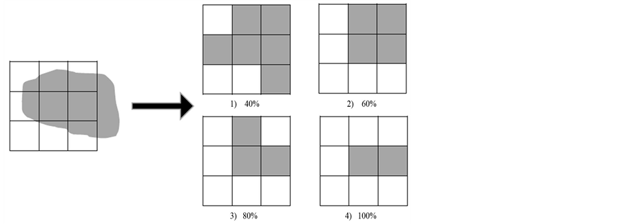
城镇核心区是完全城市化地区,人造覆盖密度大,容易提出。以行政等级对城镇核心区进行等级划分,比重指标的选取标准为a)能清晰反映中心城区和新城区的建成区位置和大致范围和b)能过滤非集中连片建设用地(见图4)。
2.2.3. 城镇边缘区
从土地利用特点来看,城镇核心区是完全城市化区域,基本没有农业用地,城镇边缘区或城乡过渡带是城市用地与乡村用地交错分布,乡村地区是以农业用地为主,基本没有城市用地的地区,建设用地比率从内到外不断降低。同时,城镇地区的土地利用开发强度远远大于乡村地区。因此划分城乡用地就是要确定城与乡分界处的用地临界值。伴随着人口的持续增长和经济的快速发展,中国正在经历快速的城市化过程。城市化过程不仅是人口与经济的转换与集中,还是一个地域空间过程。中国的快速城市化

Figure 1. Schematic diagram of data preprocessing
图1. 数据预处理示意图

Figure 2. Schematic diagram of connection method
图2. 连接方式示意图

Figure 3. Schematic diagram of decision method
图3. 主城区连接地块判定方法示意图

Figure 4. Decision rules of build-up area. Different levels of the city’s indicator is different, city center is 80%, central town is 60%
图4. 建成区栅格化判断规则。不同等级的城市中心区比重指标选取标准不同,中心城区的选取标准为80%,中心镇为60%
不仅对城市及其腹地的土地利用带来多方面的影响,也产生了城市边缘地区的土地利用快速变化与混乱状况加剧等一系列问题。针对城镇边缘区的特征,从三个方面来划分城乡。
1) 城镇建设用地比率变化度[7]
从城镇核心区经边缘区到乡村,城镇用地的比率逐渐减少,为剔除随机变化的影响,突出城镇建设用地比率圈层变化的总体特征,在城市地表覆盖用地分布图上开一定大小的窗口,统计该窗口内建设用地面积占整个窗口面积的比率,并将该统计窗口在分布图上滑动。用地比率窗口计算式如下:
 (1)
(1)
其中,N为统计窗口大小, 为城市用地分布图上的灰度值,i,j为相应的行列数,若为建设用地,则
 ;若为非建设用地,则
 。
。
2) 土地利用程度综合指数
土地利用程度综合指数[8] 反映了区域内土地利用的集约程度,应用的关键问题在于土地利用程度的分级和分级指数的设定。国内文献中的一种处理方式是根据土地利用的开发程度来分级,对四种土地利用的理想状态定为四种土地利用级,从未利用土地级、粗放利用土地级、集约用地级到城镇、聚落用地。结合其定义的内涵与外延和地表覆盖分类,对其土地利用等级分级进行调整,分级和分级指数设定如表1。
区域土地利用程度综合指数的计算方式为式(2)
 (2)
(2)
其中,Ld为某片区域土地利用程度综合指数;LC为区域内第i级土地利用面积百分比,B为第i级土地利用程度分级指数;n为土地利用程度分级数。
3) 综合土地利用动态度
土地利用动态度[9] [10] 综合考虑土地利用类型间的转移。中国的快速城市化导致了城镇边缘区的土地利用变化较大,综合土地利用动态度能从一定角度检测出城镇边缘区。动态度指数的计算公式如下:
 (3)
(3)
其中,LCC (land cover change)为综合土地利用动态度,LC (land cover)地表覆盖类型 ;j为非i类;
 表示时段内第i类土地利用类型转为非i类土地利用类型的面积;T为时段长度,此处为10年。
2.2.4. 城乡边界研究
城乡断面上城市用地的三种综合指数变化显示出一定的规律性,如图5所示。城镇核心区,建设用地比率和土地利用综合程度指数高,土地动态度低,核心区的用地几乎达到饱和状态,各项指数平稳。乡村地区的建设用地比率和土地动态度低,土地利用综合指数较高,各项指数也较为平稳。城乡过渡区位于城镇核心连续建成区和以农业土地利用为主的乡村之间,兼具城市和乡村的特征,是一个不连续空间,建设用地比率和土地利用综合指数不稳定,不是逐渐过渡的,而是出现了明显的转折。城市用地扩张导致城乡过渡带上的用地动态度高,峰值区域是用地变化最大的区域,通常为新增城市用地。根据三种指数的特征划分出三篇区域,再对城市进行随机采样,去除数据异常点后,得到城乡分界点的三种指数秦律分布表。根据样本数据的统计分析结果,找到城乡分解的参考点,得到城镇和乡村的值域区间。
3. 案例研究
3.1. 研究区域及数据来源
以武汉市为研究范围,主要对地表覆盖中的人造覆盖类型进行城乡划分。武汉市全境面积8494.41平方公里,有13个辖区,其中江岸区、江汉区、硚口区、汉阳区、武昌区、洪山区、青山区7个为中心城区,东西湖区、蔡甸区、江夏区、黄陂区、新洲区、汉南区6个为新城区。
数据来源包括:《全球地表覆盖数据分析》项目,2000、2010年武汉市Landsat遥感影像图,2000、2010年武汉市人造覆盖1等用地分布图,百万居民点分布数据等。所有数据均转换为栅格数据形式,栅格大小为30 m。

Table 1. Different types of land use classification table
表1. 不同类型土地利用分级表

Figure 5. Ratio of construction land, land utilization comprehensive index, land dynamic change of the section
图5. 建设用地比率、土地利用综合指数、土地动态度变化断面图
3.2. 模型应用与结果分析
武汉市城市综合指数分布图
将武汉市2010用地分布图处理后,对各图进行等值划分,中心城区附近得到结果如图6所示。
由图6(b)可知,当等值线为0.8时,城市核心区和周边的繁华城镇中心已大致被划分出来,但要得到精确的划分结果,还必须对城乡边界进行界定。图6(c)表示武汉市10年用地的动态变化程度,除集中在城市过渡带以外,武汉市的水域也变化较大。在进行城乡边界划分时要根据土地利用综合指数来排除水体变化的影响。
3.3. 确定城乡划分标准
样本选取尽量覆盖武汉三镇,以得出适宜的城乡临界值,并根据结果进行城乡划分。因城市大小和发展水平不同,统计时应根据三种不同城市等级分别统计。城乡分界的参考点选择见图7。
通过样本数据统计,可知武汉市城镇建设用地比率、土地利用综合指数和土地利用动态度的城乡分界参考点的平均值取整后如下表所示。三项指数中,以城镇建设用地比率为重要参考指数,土地利用综合指数和土地利用动态度指数为辅。
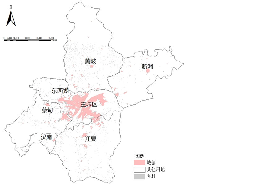
依照表2的界定标准,在GIS软件中对武汉市的人造覆盖用地进行划分,得到结果如图8。
4. 结论与讨论
建国以来,我国对城乡划分标准做过多次调整,但是随着经济的迅速发展,如何界定城市与乡村的界限是日益困难的工作。找到一种结果最大程度上接近于真实,又便于操作和大范围迅速推广的具体方
 (a)
(a) (b)
(b)
Figure 6. (a) Distribution of construction land in Wuhan; (b) Construction land ratio contour map of Wuhan; (c) Comprehensive index of land use in Wuhan; (d) Ten years land use dynamic distribution
图6. (a) 武汉市中心城区人造覆盖分布图;(b) 武汉市建设用地比率等值分布图;(c) 武汉市土地利用综合指数分等值布图;(d) 武汉市十年用地动态度等值分布图

Figure 7. Urban-rural transition zone profile
图7. 城乡过渡区断面图

Figure 8. Wuhan urban and rural artificial cover land use map, 2010
图8. 武汉市2010年城乡人造覆盖用地分布图

Table 2. Defined standards of the boundary between urban and rural areas
表2. 城乡边界界定标准
法,这是广大地理学和城市规划专业的学者们长期以来的追求。为此本文提出了可以从城市建设用地比率、土地利用综合指数和综合土地利用动态度三方面来界定标准并以武汉市为例对其城乡边界进行了划分。结果表明,综合三种指标对城乡划分是可行的,指标中城市建设用地比率具有最重要的作用。土地利用动态度虽能体现出城市边界的扩展,但受到其他因素,如水体变化的影响较大,需要结合土地利用综合指数。利用本文所提出的方法可以方便迅速地计算城市三种土地利用属性值以及划分城乡边界,进而获得整个城市的用地形态特征,从而把握城市的发展态势和规律,为城市化发展与管理提供有针对性的合理建议。
基金项目
本研究得到测绘地利信息公益性行业科研专项项目:“全球地表覆盖数据分析研究”资助。

NOTES
*通讯作者。
1人造覆盖是指由人工活动形成的由沥青、混凝土、沙石、砖瓦、玻璃以及其他建材覆盖的地表覆盖类型,根据人造覆盖的用途情况可分为居民区(城市、乡镇、村庄)、交通、通讯以及工矿等设施等类型。根据其透水情况,人造覆盖可分为透水层和不透水层。不透水层人造覆盖是指能阻挡水渗透到土壤,透水率较低的地面,包括以屋顶、沥青或水泥路面、停车场以及夯实的土壤等为主的地表;透水层人造覆盖是指水能够透过地表达到土壤,透水率比较高的地面,包括泥质道路、晒场和透水停车场等为主的地表。